


The Premier Freshwater Fishing Map
- Industry-leading coverage, clarity and detail with updated inland maps that feature integrated Garmin and Navionics® content
- Coverage for more than 13,500 total lakes, of which more than 4,800 have up to 1’ contours
- Auto Guidance¹ technology quickly calculates a suggested route by using your desired depth and overhead clearance
- Depth Range Shading for up to 10 depth ranges enables you to view your target depth at a glance
Download the ActiveCaptain® app to use OneChart™, which gives you access to all your charts and maps from your mobile device and even lets you purchase new ones.
¹Auto Guidance is for planning purposes only and does not replace safe navigation practices
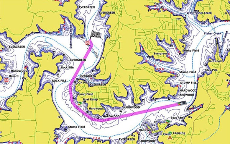
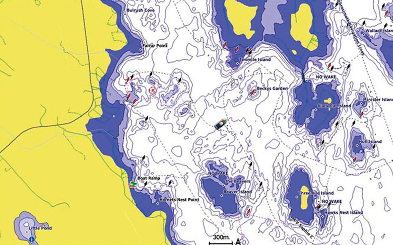
Auto Guidance
Whether you are fishing or cruising, select a spot, and get a route showing you the general path and nearby obstructions at a safe depth¹.
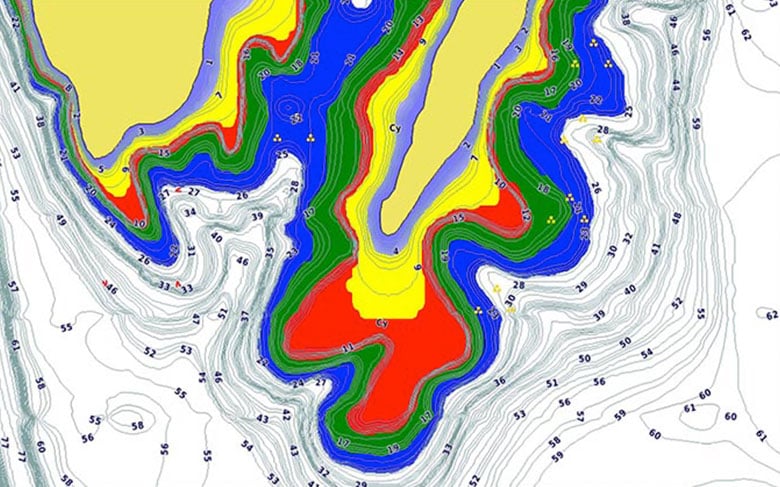
Depth Range Shading
This feature displays high-resolution Depth Range Shading for up to 10 depth ranges so you can view your designated target depth.
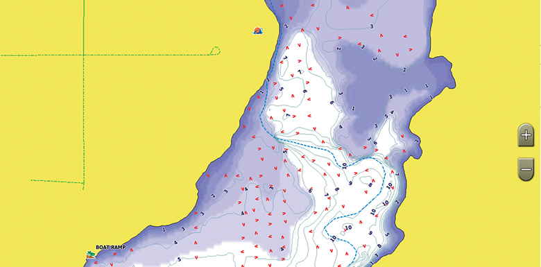
Shallow Water Shading
To give a clear picture of shallow waters to avoid, this feature allows for shading at a user-defined depth.
Dynamic Lake Level
This feature allows you to adjust your maps to the lake’s current water levels, giving you a better idea of spots that are either accessible or too shallow to explore.
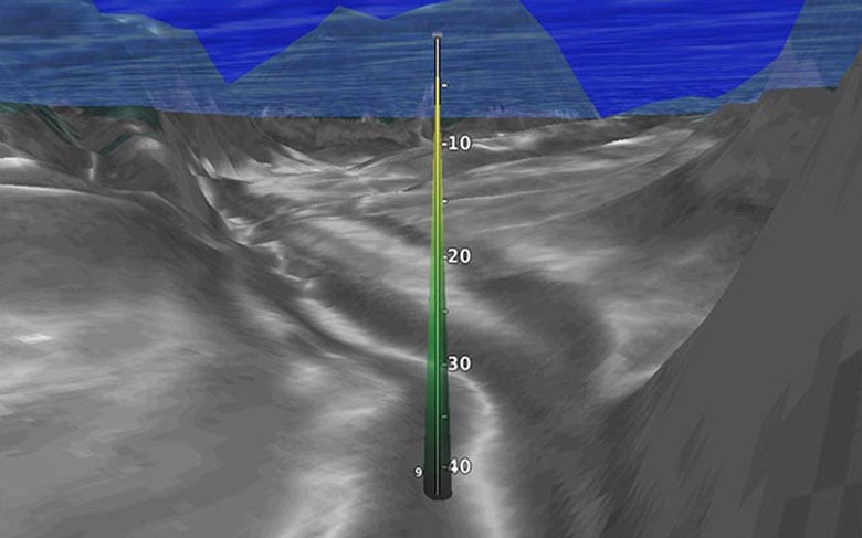
FishEye View
This underwater perspective shows 3-D representation of lake bottom and contours as seen from below the waterline. Interface with sonar data for a customized view.
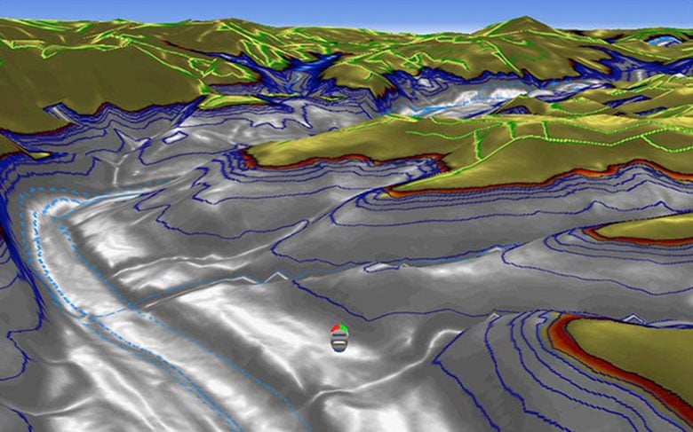
MarinerEye View
This view provides a 3-D representation of the surrounding area both above and below the waterline.
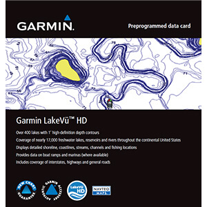
Coverage on over 17,000 total lakes, of which 13,000 are HD maps with up to 1′ contours that provide a clearer view of the lake floor so you can catch more fish and navigate with confidence
Depth Range Shading for up to 10 depth ranges enables you to view your target depth at a glance
Shallow Water Shading lets you input and shade a minimum depth to help you avoid running aground
Displays points of interest, campgrounds, highways and roads as well as underwater features like riverbeds, fish attractors and potential hazards
Displays high-resolution Depth Range Shading for up to 10 depth ranges so you can view your designated target depth.
Industry-leading coverage, clarity and detail with updated inland maps that feature integrated Garmin and Navionics® content
Coverage for more than 13,500 total lakes, of which more than 4,800 have 1’ contours
Auto Guidance technology quickly calculates a suggested route by using your desired depth and overhead clearance
Includes Depth Range Shading for up to 10 depth ranges, enabling you to view your target depth at a glance
To give a clear picture of shallow waters to avoid, the Shallow Water Shading feature allows for shading at a user-defined depth
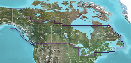
Experience unparalleled coverage and brilliant detail when you’re on the water. Canada LakeVü g3 inland maps provide industry-leading coverage, clarity and detail with updated inland maps that feature integrated Garmin and Navionics content.
Auto Guidance – Whether you are fishing or cruising, select a spot, and get a route showing you the general path and nearby obstructions at a safe depth1.
Depth Range Shading – This feature displays high-resolution Depth Range Shading for up to 10 depth ranges so you can view your designated target depth.
Shallow Water Shading – To give a clear picture of shallow waters to avoid, this feature allows for shading at a user-defined depth.
Access Your Charts and Maps – Download the ActiveCaptain® app to use OneChart™, which gives you access to all your charts and maps from your mobile device and even lets you purchase new ones.
1Auto Guidance is for planning purposes only and does not replace safe navigation practices. Auto Guidance is not included in preloaded LakeVü g3 for ECHOMAP™ Plus series chartplotters.
Canada
Specifications
Navionics® data Yes
Total lakes covered 13,500+
Garmin Elite surveyed lakes No
Fish attractors No
Auto Guidance technology Yes
High-resolution relief shading No
Depth range shading Yes
Shallow water shading Yes
Unique 3-D views No
Dynamic lake level No
High-resolution satellite imagery No
Surface and side scan sonar photos No
Industry-leading coverage, clarity and detail with updated inland maps that feature integrated Garmin and Navionics® content
Coverage for more than 13,500 total lakes, of which more than 4,800 have up to 1’ contours
Auto Guidance technology quickly calculates a suggested route by using your desired depth and overhead clearance
High-resolution Relief Shading makes it easier to see contours and find fish holding structure
Depth Range Shading for up to 10 depth ranges enables you to view your target depth at a glance
Experience unparalleled coverage and brilliant detail when you’re on the water. Canada LakeVü g3 Ultra inland maps provide industry-leading coverage, clarity and detail with integrated Garmin and Navionics content.
Auto Guidance – Whether you are fishing or cruising, select a spot, and get a route showing you the general path and nearby obstructions at a safe depth1.
High-resolution Relief Shading – The High-resolution Relief Shading feature adds visual depth to the 2-D map, making it easier to interpret contours and find fish holding structure.
Depth Range Shading – This feature displays high-resolution Depth Range Shading for up to 10 depth ranges so you can view your designated target depth.
Shallow Water Shading – To give a clear picture of shallow waters to avoid, this feature allows for shading at a user-defined depth.
Dynamic Lake Level – This feature allows you to adjust your maps to the lake’s current water levels, giving you a better idea of spots that are either accessible or too shallow to explore.
FishEye View – This underwater perspective shows 3-D representation of lake bottom and contours as seen from below the waterline. Interface with sonar data for a customized view.
MarinerEye View – This view provides a 3-D representation of the surrounding area both above and below the waterline.
Access Your Charts and Maps – Download the ActiveCaptain® app to use OneChart™, which gives you access to all your charts and maps from your mobile device and even lets you purchase new ones.
1Auto Guidance is for planning purposes only and does not replace safe navigation practices
Canada
Specifications
Navionics® data Yes
Total lakes covered 13,500+
Garmin Elite surveyed lakes No
Fish attractors No
Auto Guidance technology Yes
High-resolution relief shading No
Depth range shading Yes
Shallow water shading Yes
Unique 3-D views Yes
Dynamic lake level Yes
High-resolution satellite imagery No
Surface and side scan sonar photos No
Provides industry-leading coverage, clarity and detail for more than 17,000 lakes with 1’ contours that feature integrated Garmin and Navionics® data
Auto Guidance technology uses your desired depth and overhead clearance to calculate routes and show a suggested path to follow
Coverage for more than 17,000 lakes, of which more than 150 are Garmin Elite survey lakes with up to 1’ contours
High-resolution relief shading combines color and shadow to give you an easy-to-interpret, clearer view of bottom structure than contour lines alone
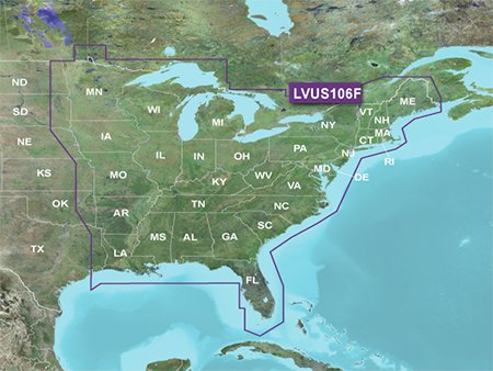
The East card covers more than 11,500 HD lakes with up to 1’ contours and more than 100 Garmin Elite survey lakes
Experience unparalleled coverage and brilliant detail on the water. LakeVü g3 Ultra inland water maps provide industry-leading coverage, clarity and detail with integrated Garmin and Navionics data, Auto Guidance technology and high-resolution relief shading.
The Auto Guidance feature uses your desired depth and overhead clearance to calculate a route and suggest a path to follow.
High-resolution relief shading combines color and shadow to give you an easy-to-interpret, clearer view of bottom structure than contour lines alone.
You can adjust your maps to the lake’s current water level to have a better idea of spots that are either accessible or too shallow to explore.
MarinerEye and FishEye views provide additional perspective both above and below the water line.
Auto Guidance is for planning purposes only and does not replace safe navigation operations
Covers the continental U.S. east of the Mississippi River
Provides industry-leading coverage, clarity and detail for more than 17,000 lakes with 1’ contours that feature integrated Garmin and Navionics® data
Auto Guidance technology uses your desired depth and overhead clearance to calculate routes and show a suggested path to follow
Coverage for more than 17,000 lakes, of which more than 150 are Garmin Elite survey lakes with up to 1’ contours
High-resolution relief shading combines color and shadow to give you an easy-to-interpret, clearer view of bottom structure than contour lines alone
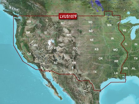
The West card covers more than 5,900 HD lakes with up to 1’ contours, and more than 75 Garmin Elite survey lakes
Experience unparalleled coverage and brilliant detail on the water. LakeVü g3 Ultra inland water maps provide industry-leading coverage, clarity and detail with integrated Garmin and Navionics data, Auto Guidance technology and high-resolution relief shading.
The Auto Guidance feature uses your desired depth and overhead clearance to calculate a route and suggest a path to follow.
High-resolution relief shading combines color and shadow to give you an easy-to-interpret, clearer view of bottom structure than contour lines alone.
You can adjust your maps to the lake’s current water level to have a better idea of spots that are either accessible or too shallow to explore.
MarinerEye and FishEye views provide additional perspective both above and below the water line.
Covers the continental U.S. west of the Mississippi River


Amy Taylor –
You want the Best, here it is!!! Don’t go out on the lake without it! Totally satisfied!! You will be too!