


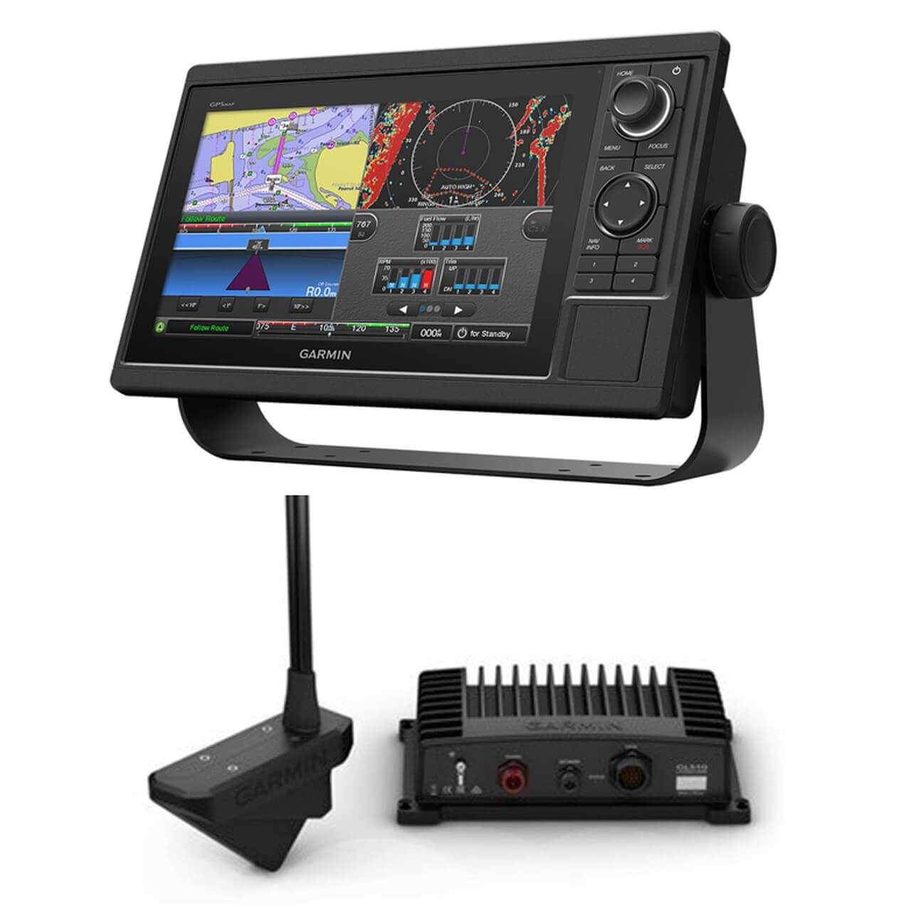


Our Garmin Panoptix Bundle comes with your choice of graph, the LiveScope system and the Perspective Mode Mount.
Garmin Graphs available
GPSMAP 1222 12″ Plotter Worldwide Basemap
GPSMAP 1222XSV 12″ Combo Basemap No transducer
GPSMAP 1022XSV 10″ Combo Basemap No transducer
GPSMAP 1042XSV 10″ Combo US Lakes & Coast No transducer
GPSMAP 1022 10″ Plotter Worldwide Basemap
ECHOMAP Ultra 2 102sv GT56UHD-TM transducer
ECHOMAP Ultra 2 102sv No transducer
ECHOMAP Ultra 2 122sv GT56UHD-TM transducer
ECHOMAP Ultra 2 122sv No transducer
ECHOMAP UHD2 72sv Worldwide Basemap No Transducer
ECHOMAP UHD2 72sv Worldwide Basemap with GT54 Transducer
ECHOMAP UHD2 73cv Combo US LakeVu g3 with GT20-TM Transducer
ECHOMAP UHD2 73cv U.S. Inland GN+ with GT20-TM Transducer
ECHOMAP UHD2 73cv US Lakes and Rivers GN+ No Transducer
ECHOMAP UHD2 73cv US Lakes and Rivers GN+ with GT54-TM Transducer
ECHOMAP UHD2 74cv Combo US BlueChart g3 with GT20-TM Transducer
ECHOMAP UHD2 74cv Combo US Coastal GN+ with GT20-TM Transducer
ECHOMAP UHD2 74sv US Coastal and Great Lakes GN+ No Transducer
ECHOMAP UHD2 74sv US Coastal and Great Lakes GN+ with GT54 Transducer
ECHOMAP UHD2 92sv Worldwide Basemap No Transducer
ECHOMAP UHD2 92sv Worldwide Basemap with GT56 Transducer
ECHOMAP UHD2 93sv US Lakes and Rivers GN+ No Transducer
ECHOMAP UHD2 93sv US Lakes and Rivers GN+ with GT56 Transducer
ECHOMAP UHD2 94sv US Coastal and Great Lakes GN+ No Transducer
ECHOMAP UHD2 94sv US Coastal and Great Lakes GN+ with GT56 Transducer
Garmin Livescopes available
Livescope
Livescope Plus
Garmin Panoptix LiveScope™ System
Garmin Perspective Mode Mount
Option Details
Garmin Perspective Mode Mount for LiveScope
Model: 010-12970-0
- One mount, three views so you can see all around your boat in real time.
- Easily mount to your trolling motor.
- Your chartplotter automatically detects which mode you’re in.
- Rough waters won’t affect sonar so you can fish through anything.
Adjust the transducer to fit how you fish. This mount gives you real-time images of what’s all around and ahead of your boat plus an overhead view for shallow water.
Update the software on your compatible chartplotter1 to get auto-detection of each mode right on your chartplotter screen.
The attitude heading reference system (AHRS) keeps sonar view stable even in rough conditions.
1 Compatible with GPSMAP® 8400/8600 series MFDs, GPSMAP 7400/7600, 1002/1202, GPSMAP 1202/1202xsv Touch, 702/902 series chartplotters and X2 Plus series and ECHOMAP™ Plus 70cv/70sv and ECHOMAP UHD and 90sv chartplotter/sonar combo series
The Perspective Mode Mount takes your LiveScope™ Plus real-time scanning sonar to the next level. Attach your LVS34 transducer to this mount to add an overhead sonar view that’s perfect for scouting and fishing in shallow water.
Garmin Panoptix LiveScope™ System
Model: 010-01864-00
- See highly detailed, easy-to-interpret live scanning sonar images of structure, bait and fish swimming below and around your boat in real time, even when your boat is stationary
- Easily adjust the transducer to fit your fishing techniques; point forward to see around your boat, or point down to see directly below your boat
- Attitude Heading Reference System (AHRS) stabilizes sonar view on chartplotter screen, even in rough conditions
- See incredibly sharp real-time scanning sonar images up to 200’ down and away
- Simple plug-and-play Garmin Marine Network connector makes it easy to install and seamlessly integrate with your compatible Garmin chartplotter
Clearly, this is the most amazing sonar technology ever. You have never fished like this before. Panoptix LiveScope is live, real-time scanning sonar. You can actually see easy-to-interpret live scanning sonar images of fish swimming near clearly defined structure. You can even see your lure as you retrieve it. And your boat doesn’t need to be moving. These images are so clear and precise that with a little practice, you might be able to distinguish between species of fish!
You get both LiveScope™ Down and LiveScope™ Forward modes in one transducer. It’s easy to adjust the transducer mode to fit your fishing techniques; use LiveScope Forward to see remarkably clear images of structure and swimming fish around your boat, and use LiveScope Down to see directly below your boat. The view automatically updates on your compatible Garmin chartplotter. AHRS stabilization keeps your sonar view steady, even in rough conditions.
LiveScope Down mode allows you to see live, easy-to-interpret scanning sonar images of structure and swimming fish in incredible detail below your boat —up to 200’ — even while your boat is stationary.
LiveScope Forward mode is an excellent tool for scouting and fishing out ahead of your cast. You’re looking at live, highly detailed and easy-to-interpret scanning sonar images of structure and fish swimming all around your boat — up to 200’ — even while your boat is stationary.
The Panoptix LiveScope scanning sonar system includes a compact GLS 10 sonar black box with LVS32 transducer and simple plug-and-play Garmin Marine Network connector, making it easy to install and seamlessly integrate with your compatible Garmin chartplotter. Use the transducer as a supplemental traditional and ClearVü sonar source to see a historical representation of structure and fish below your boat.
Specifications
| Water rating | IPX7 |
| Garmin Marine Network™ ports | 1 (small connector) |
| Temperature range | Operating: -15 C to 70 C; Non-operating: -40 C to 85 C |
| Sonar Features & Specifications | |
| Frequencies supported | 530 – 1,100 kHz |
| Transmit power | 500 W |
| Maximum depth | Down and Forward: 200’ (61.0 m) |
| Electrical | |
| Power input | 10-32 V |
| Power usage | 21 W typical, 58 W max |
| Fuse | 7.5 A |
| Other | |
| Dimensions | GLS 10 sonar black box: 9.6″ x 5.9″ x 2.6″ (24.5 x 14.9 x 6.5 cm); LVS32 transducer: 5.4″ x 3.8″ x 1.8″ (13.7 x 9.7 x 4.6 cm) |
What’s in the Box:
- LiveScope GLS 10 sonar black box
- Panoptix LVS32 transducer
- Trolling motor barrel mount
- Trolling motor shaft mount
- Transom mount
- Power cable
- 2 meter Garmin marine network cable, small connector
- Network adapter cable
- Mounting hardware
- Documentation
Garmin Panoptics Livescope Plus
Model: 010-02706-00
- See images clearly with improved screen clarity, transducer sensitivity and target separation.
- Scan surroundings with sharper images, reduced noise and fewer sonar artifacts.
- Upgrade your current LiveScope System black box (GLS™ 10 sonar module) with just a new transducer.
- Get maximum contrast and clarity in your images with vivid color palettes.
- Don’t miss a thing with supported Forward, Down and Perspective modes and necessary mount.
The latest in LiveScope technology, the LiveScope Plus System offers improved resolution, reduced noise, clearer images and better target separation.
Real-time sonar ensures that your live images are as accurate as possible.
See exactly what you need with reduced noise and fewer sonar artifacts that impede your picture of fish and structure.
A built-in stabilization system keeps the sonar image on your compatible chartplotter steady, even in rough conditions.
Choose from seven vivid color options — including Aqua, Caribbean, Lava and more — to see fish and structure in maximum contrast and clarity.
Scout ahead of your boat to see what’s happening in real time.
Explore live views of the activity directly beneath your boat.
See under the water with a view from your perspective above the water.
Specifications
| DIMENSION | GLS 10 sonar black box: 9.7″ x 5.9″ x 2.6″ (24.5 x 14.9 x 6.5 cm); LVS34 transducer: 6.4″ x 3.1″ x 1.9″ (16.2 x 7.8 x 4.8 cm) |
| WEIGHT | GLS 10 sonar black box: 4.3 lbs (2.0 kg); LVS34 transducer: 2.25 lbs (1.02 kg) |
| WATERPROOF | IPX7 |
| TEMPERATURE RANGE | GLS 10 Black Box: Operating: -15 C to 70 C Panoptix LiveScope LVS34 Transducer: Operating: 0 C to 40 C |
| Sonar Features & Specifications | |
| FREQUENCY | 530 – 1,100 kHz |
| MAXDEPTH | Down and Forward: 200’ (61.0 m) |
| Connections | |
| CONNECTIONS GARMIN MARINE NETWORK PORTS | 1 (small connector) |
| Electrical Features | |
| POWER INPUT | 10-32 V |
| POWER USAGE | 21 W typical, 58 W max |
| TRANSMIT POWER | 500 W |
| FUSE | 7.5 A |
| COMPASS-SAFE DISTANCE | 4″ (0.1 m) |
| Additional | |
| Minimum depth | 3′ (0.91 m) |
| Sonar type | Live |
| Beamwidth | 20° x 135° |
| Transducer cable length | 20 ft |
| Transducer number of pins | 21 |
What’s in the Box:
- LiveScope GLS 10 sonar black box
- Panoptix LVS34 transducer
- Perspective mount
- Trolling motor barrel mount
- Shaft mount
- Power cable
- 2 meter Garmin Marine Network cable (small connector)
- Network adapter cable
- Documentation
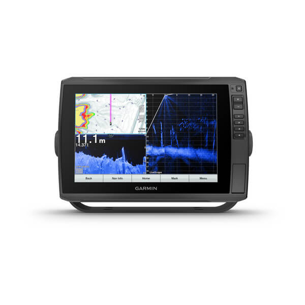
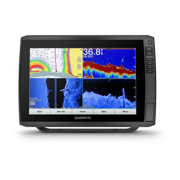
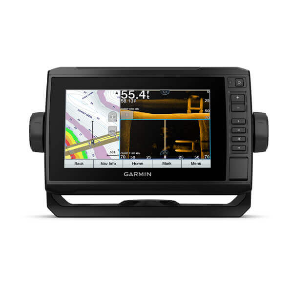
Garmin ECHOMAP™ Ultra 102sv 10″ Chartplotters with GT56UHD-TM Transducer
Model: 010-02879-01
- SUPPORTS LIVESCOPE™ SONAR1 AND MORE
- WIRELESSLY NETWORK; SHARE SONAR, WAYPOINTS AND ROUTES2
- CAPTURE SCREEN RECORDINGS TO SHARE FISH CATCHES
- MULTI-BAND GPS FOR IMPROVED POSITION ACCURACY
With big, crisp, sunlight-readable touchscreen displays, these versatile chartplotters put a world of fishfinding capability at your fingertips. They’re available with built-in Garmin Navionics+™ mapping, and the transducer bundle adds Ultra High-Definition scanning sonars as well as CHIRP traditional sonar.
The ECHOMAP Ultra 2 series supports the full lineup of LiveScope live-scanning sonar products (transducers sold separately).
High-contrast vivid scanning sonar color palettes make it easier than ever to distinguish targets and structure.
Bring a fresh new look and feel to your chartplotter with optional Garmin Navionics Vision+™ premium mapping (sold separately), featuring high-resolution relief shading, satellite imagery and more.
If you have another compatible ECHOMAP Ultra 2 or ECHOMAP UHD2 chartplotter on your boat, you can wirelessly share information — such as sonar, waypoints and routes — with them.
LiveScope™ System sonar transducer sold separately Via one-to-one unit wireless connection only LiveScope sonar cannot be shared wirelessly between two ECHOMAP Ultra 2 or ECHOMAP UHD2 chartplotters Requires the ActiveCaptain app on your compatible smartphone paired to your ECHOMAP Ultra 2 series chartplotter
Specifications
| General | |
| DIMENSION | 11.6″ x 7.7″ x 3.9″ (29.5 x 19.5 x 9.8 cm) |
| WEIGHT | 4.0 lbs (1.8 kg) |
| WATERPROOF | IPX7 |
| TOUCHSCREEN | Yes |
| DISPLAY TYPE | WXGA, IPS |
| DISPLAY SIZE | 8.5″ x 5.4″; 10″ diagonal (21.7 x 13.6 cm; 25.4 cm diagonal) |
| DISPLAY RESOLUTION | 1280 x 800 pixels |
| MOUNTING OPTIONS | Bail or flush |
| INPUT | Touchscreen with Keyed Assist |
| Maps & Memory | |
| ACCEPTS DATA CARDS | 2 microSD cards |
| WAYPOINTS | 5000 |
| TRACK POINTS | 50,000 |
| TRACKS | 50 saved tracks |
| NAVIGATION ROUTES | 100 |
| Sensors | |
| GPS | Yes |
| GLONASS | Yes |
| GALILEO | Yes |
| BEIDOU | Yes |
| HAS BUILT-IN RECEIVER | Yes |
| RECEIVER | 10 Hz |
| NMEA 2000 COMPATIBLE | Yes |
| NMEA 0183 COMPATIBLE | Yes |
| SUPPORTS WAAS | Yes |
| SUPPORTS MULTI-BAND, MULTI-CONSTELLATION GPS | Yes |
| Built-in Maps | |
| BUILT-IN AUTO GUIDANCE+ | Yes |
| GARMIN NAVIONICS+ INLAND & COASTAL | No |
| TIDE TABLES | No |
| Optional Map Support | |
| BLUECHART G3 | Yes |
| BLUECHART G3 VISION | Yes |
| LAKEVü G3 | Yes |
| LAKEVü G3 ULTRA | Yes |
| GARMIN NAVIONICS+™ | Yes |
| GARMIN NAVIONICS VISION+™ | Yes |
| TOPO 100K | Yes |
| STANDARD MAPPING | Yes |
| GARMIN QUICKDRAW CONTOURS | Yes |
| Electrical Features | |
| POWER INPUT | 9 to 18 Vdc |
| TYPICAL CURRENT DRAW AT 12 VDC | 2.3 A |
| MAXIMUM CURRENT DRAW AT 12 VDC | 5.0 A |
| MAXIMUM POWER USAGE AT 10 VDC | 34 W |
| Connections | |
| NMEA 2000® PORTS | 1 |
| GARMIN MARINE NETWORK PORTS | 2 (large connector) |
| 12-PIN TRANSDUCER PORTS | 12-pin scanning sonar |
| ANT+ (CONNECTIVITY) | Yes |
| GARMIN WI-FI NETWORK (LOCAL CONNECTION) | Yes |
| Sonar Features | |
| DISPLAYS SONAR | Yes |
| POWER OUTPUT | 600 watt |
| TRADITIONAL SONAR (DUAL FREQUENCY/BEAM) | built-in (single channel CHIRP, 70/83/200 kHz, L, M, H CHIRP) |
| CLEARVü | built-in 260/455/800/1000/1200 kHz |
| SIDEVü | built-in 260/455/800/1000/1200 kHz |
| PANOPTIX™ SONAR | Yes |
| LIVESCOPE | Yes |
What’s in the Box:
- ECHOMAP Ultra 102sv
- Power/data cable
- Bail mount with quick release cradle
- Protective sun cover
- GT56UHD-TM transducer
- Hardware
- Documentation
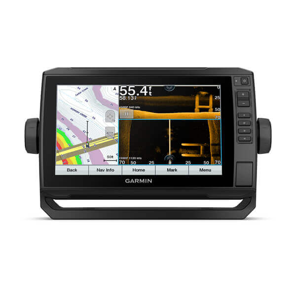
Garmin ECHOMAP™ Ultra 2 102sv 10″ Chartplotters without Transducer
Model: 010-02879-00
- SUPPORTS LIVESCOPE™ SONAR1 AND MORE
- WIRELESSLY NETWORK; SHARE SONAR, WAYPOINTS AND ROUTES2
- CAPTURE SCREEN RECORDINGS TO SHARE FISH CATCHES
- MULTI-BAND GPS FOR IMPROVED POSITION ACCURACY
With big, crisp, sunlight-readable touchscreen displays, these versatile chartplotters put a world of fishfinding capability at your fingertips. They’re available with built-in Garmin Navionics+™ mapping, and the transducer bundle adds Ultra High-Definition scanning sonars as well as CHIRP traditional sonar.
The ECHOMAP Ultra 2 series supports the full lineup of LiveScope live-scanning sonar products (transducers sold separately).
High-contrast vivid scanning sonar color palettes make it easier than ever to distinguish targets and structure.
Bring a fresh new look and feel to your chartplotter with optional Garmin Navionics Vision+™ premium mapping (sold separately), featuring high-resolution relief shading, satellite imagery and more.
If you have another compatible ECHOMAP Ultra 2 or ECHOMAP UHD2 chartplotter on your boat, you can wirelessly share information — such as sonar, waypoints and routes — with them.
LiveScope™ System sonar transducer sold separately Via one-to-one unit wireless connection only LiveScope sonar cannot be shared wirelessly between two ECHOMAP Ultra 2 or ECHOMAP UHD2 chartplotters Requires the ActiveCaptain app on your compatible smartphone paired to your ECHOMAP Ultra 2 series chartplotter
Specifications
| General | |
| DIMENSION | 11.6″ x 7.7″ x 3.9″ (29.5 x 19.5 x 9.8 cm) |
| WEIGHT | 4.0 lbs (1.8 kg) |
| WATERPROOF | IPX7 |
| TOUCHSCREEN | Yes |
| DISPLAY TYPE | WXGA, IPS |
| DISPLAY SIZE | 8.5″ x 5.4″; 10″ diagonal (21.7 x 13.6 cm; 25.4 cm diagonal) |
| DISPLAY RESOLUTION | 1280 x 800 pixels |
| MOUNTING OPTIONS | Bail or flush |
| INPUT | Touchscreen with Keyed Assist |
| Maps & Memory | |
| ACCEPTS DATA CARDS | 2 microSD cards |
| WAYPOINTS | 5000 |
| TRACK POINTS | 50,000 |
| TRACKS | 50 saved tracks |
| NAVIGATION ROUTES | 100 |
| Sensors | |
| GPS | Yes |
| GLONASS | Yes |
| GALILEO | Yes |
| BEIDOU | Yes |
| HAS BUILT-IN RECEIVER | Yes |
| RECEIVER | 10 Hz |
| NMEA 2000 COMPATIBLE | Yes |
| NMEA 0183 COMPATIBLE | Yes |
| SUPPORTS WAAS | Yes |
| SUPPORTS MULTI-BAND, MULTI-CONSTELLATION GPS | Yes |
| Built-in Maps | |
| BUILT-IN AUTO GUIDANCE+ | Yes |
| GARMIN NAVIONICS+ INLAND & COASTAL | No |
| TIDE TABLES | No |
| Optional Map Support | |
| BLUECHART G3 | Yes |
| BLUECHART G3 VISION | Yes |
| LAKEVü G3 | Yes |
| LAKEVü G3 ULTRA | Yes |
| GARMIN NAVIONICS+™ | Yes |
| GARMIN NAVIONICS VISION+™ | Yes |
| TOPO 100K | Yes |
| STANDARD MAPPING | Yes |
| GARMIN QUICKDRAW CONTOURS | Yes |
| Electrical Features | |
| POWER INPUT | 9 to 18 Vdc |
| TYPICAL CURRENT DRAW AT 12 VDC | 2.3 A |
| MAXIMUM CURRENT DRAW AT 12 VDC | 5.0 A |
| MAXIMUM POWER USAGE AT 10 VDC | 34 W |
| Connections | |
| NMEA 2000® PORTS | 1 |
| GARMIN MARINE NETWORK PORTS | 2 (large connector) |
| 12-PIN TRANSDUCER PORTS | 12-pin scanning sonar |
| ANT+ (CONNECTIVITY) | Yes |
| GARMIN WI-FI NETWORK (LOCAL CONNECTION) | Yes |
| Sonar Features | |
| DISPLAYS SONAR | Yes |
| POWER OUTPUT | 600 watt |
| TRADITIONAL SONAR (DUAL FREQUENCY/BEAM) | built-in (single channel CHIRP, 70/83/200 kHz, L, M, H CHIRP) |
| CLEARVü | built-in 260/455/800/1000/1200 kHz |
| SIDEVü | built-in 260/455/800/1000/1200 kHz |
| PANOPTIX™ SONAR | Yes |
| LIVESCOPE | Yes |
What’s in the Box:
- ECHOMAP Ultra 102sv
- Power/data cable
- Bail mount with quick release cradle
- Protective sun cover
- 8-pin transducer to 12-pin sounder adapter cable
- Hardware
- Documentation
Garmin ECHOMAP™ Ultra 2 122sv 12″ Chartplotters with GT56UHD-TM Transducer
Model: 010-02881-01
- SUPPORTS LIVESCOPE™ SONAR1 AND MORE
- WIRELESSLY NETWORK; SHARE SONAR, WAYPOINTS AND ROUTES2
- CAPTURE SCREEN RECORDINGS TO SHARE FISH CATCHES
- MULTI-BAND GPS FOR IMPROVED POSITION ACCURACY
With big, crisp, sunlight-readable touchscreen displays, these versatile chartplotters put a world of fishfinding capability at your fingertips. They’re available with built-in Garmin Navionics+™ mapping, and the transducer bundle adds Ultra High-Definition scanning sonars as well as CHIRP traditional sonar.
The ECHOMAP Ultra 2 series supports the full lineup of LiveScope live-scanning sonar products (transducers sold separately).
High-contrast vivid scanning sonar color palettes make it easier than ever to distinguish targets and structure.
Bring a fresh new look and feel to your chartplotter with optional Garmin Navionics Vision+™ premium mapping (sold separately), featuring high-resolution relief shading, satellite imagery and more.
If you have another compatible ECHOMAP Ultra 2 or ECHOMAP UHD2 chartplotter on your boat, you can wirelessly share information — such as sonar, waypoints and routes — with them.
LiveScope™ System sonar transducer sold separately Via one-to-one unit wireless connection only LiveScope sonar cannot be shared wirelessly between two ECHOMAP Ultra 2 or ECHOMAP UHD2 chartplotters Requires the ActiveCaptain app on your compatible smartphone paired to your ECHOMAP Ultra 2 series chartplotter
Specifications
| General | |
| DIMENSION | 13.4″ x 9.0″ x 3.9″ (34.1 x 22.9 x 9.8 cm) |
| WEIGHT | 5.5 lbs (2.5 kg) |
| WATERPROOF | IPX7 |
| TOUCHSCREEN | Yes |
| DISPLAY TYPE | WXGA, IPS |
| DISPLAY SIZE | 10.3″ x 6.4″; 12.1″ diagonal (26.1 x 16.3 cm; 30.7 cm diagonal) |
| DISPLAY RESOLUTION | 1280 x 800 pixels |
| MOUNTING OPTIONS | Bail or flush |
| INPUT | Touchscreen with Keyed Assist |
| Maps & Memory | |
| ACCEPTS DATA CARDS | 2 microSD cards |
| WAYPOINTS | 5000 |
| TRACK POINTS | 50,000 |
| TRACKS | 50 saved tracks |
| NAVIGATION ROUTES | 100 |
| Sensors | |
| GPS | Yes |
| GLONASS | Yes |
| GALILEO | Yes |
| BEIDOU | Yes |
| HAS BUILT-IN RECEIVER | Yes |
| RECEIVER | 10 Hz |
| NMEA 2000 COMPATIBLE | Yes |
| NMEA 0183 COMPATIBLE | Yes |
| SUPPORTS WAAS | Yes |
| SUPPORTS MULTI-BAND, MULTI-CONSTELLATION GPS | Yes |
| Built-in Maps | |
| BUILT-IN AUTO GUIDANCE+ | Yes |
| GARMIN NAVIONICS+ INLAND & COASTAL | No |
| TIDE TABLES | No |
| Optional Map Support | |
| BLUECHART G3 | Yes |
| BLUECHART G3 VISION | Yes |
| LAKEVü G3 | Yes |
| LAKEVü G3 ULTRA | Yes |
| GARMIN NAVIONICS+™ | Yes |
| GARMIN NAVIONICS VISION+™ | Yes |
| TOPO 100K | Yes |
| STANDARD MAPPING | Yes |
| GARMIN QUICKDRAW CONTOURS | Yes |
| Electrical Features | |
| POWER INPUT | 9 to 18 Vdc |
| TYPICAL CURRENT DRAW AT 12 VDC | 2.5 A |
| MAXIMUM CURRENT DRAW AT 12 VDC | 5.0 A |
| MAXIMUM POWER USAGE AT 10 VDC | 36 W |
| Connections | |
| NMEA 2000® PORTS | 1 |
| GARMIN MARINE NETWORK PORTS | 2 (large connector) |
| 12-PIN TRANSDUCER PORTS | 12-pin scanning sonar |
| ANT+ (CONNECTIVITY) | Yes |
| GARMIN WI-FI NETWORK (LOCAL CONNECTION) | Yes |
| Sonar Features | |
| DISPLAYS SONAR | Yes |
| POWER OUTPUT | 600 watt |
| TRADITIONAL SONAR (DUAL FREQUENCY/BEAM) | built-in (single channel CHIRP, 70/83/200 kHz, L, M, H CHIRP) |
| CLEARVü | built-in 260/455/800/1000/1200 kHz |
| SIDEVü | built-in 260/455/800/1000/1200 kHz |
| PANOPTIX™ SONAR | Yes |
| LIVESCOPE | Yes |
What’s in the Box:
- ECHOMAP Ultra 122sv
- Power/data cable
- Bail mount with quick release cradle
- Protective sun cover
- GT56UHD-TM ransducer
- Hardware
- Documentation
Garmin ECHOMAP™ Ultra 2 122sv 12″ Chartplotters without Transducer
Model: 010-02881-00
- SUPPORTS LIVESCOPE™ SONAR1 AND MORE
- WIRELESSLY NETWORK; SHARE SONAR, WAYPOINTS AND ROUTES2
- CAPTURE SCREEN RECORDINGS TO SHARE FISH CATCHES
- MULTI-BAND GPS FOR IMPROVED POSITION ACCURACY
With big, crisp, sunlight-readable touchscreen displays, these versatile chartplotters put a world of fishfinding capability at your fingertips. They’re available with built-in Garmin Navionics+™ mapping, and the transducer bundle adds Ultra High-Definition scanning sonars as well as CHIRP traditional sonar.
The ECHOMAP Ultra 2 series supports the full lineup of LiveScope live-scanning sonar products (transducers sold separately).
High-contrast vivid scanning sonar color palettes make it easier than ever to distinguish targets and structure.
Bring a fresh new look and feel to your chartplotter with optional Garmin Navionics Vision+™ premium mapping (sold separately), featuring high-resolution relief shading, satellite imagery and more.
If you have another compatible ECHOMAP Ultra 2 or ECHOMAP UHD2 chartplotter on your boat, you can wirelessly share information — such as sonar, waypoints and routes — with them.
LiveScope™ System sonar transducer sold separately Via one-to-one unit wireless connection only LiveScope sonar cannot be shared wirelessly between two ECHOMAP Ultra 2 or ECHOMAP UHD2 chartplotters Requires the ActiveCaptain app on your compatible smartphone paired to your ECHOMAP Ultra 2 series chartplotter
Specifications
| General | |
| DIMENSION | 13.4″ x 9.0″ x 3.9″ (34.1 x 22.9 x 9.8 cm) |
| WEIGHT | 5.5 lbs (2.5 kg) |
| WATERPROOF | IPX7 |
| TOUCHSCREEN | Yes |
| DISPLAY TYPE | WXGA, IPS |
| DISPLAY SIZE | 10.3″ x 6.4″; 12.1″ diagonal (26.1 x 16.3 cm; 30.7 cm diagonal) |
| DISPLAY RESOLUTION | 1280 x 800 pixels |
| MOUNTING OPTIONS | Bail or flush |
| INPUT | Touchscreen with Keyed Assist |
| Maps & Memory | |
| ACCEPTS DATA CARDS | 2 microSD cards |
| WAYPOINTS | 5000 |
| TRACK POINTS | 50,000 |
| TRACKS | 50 saved tracks |
| NAVIGATION ROUTES | 100 |
| Sensors | |
| GPS | Yes |
| GLONASS | Yes |
| GALILEO | Yes |
| BEIDOU | Yes |
| HAS BUILT-IN RECEIVER | Yes |
| RECEIVER | 10 Hz |
| NMEA 2000 COMPATIBLE | Yes |
| NMEA 0183 COMPATIBLE | Yes |
| SUPPORTS WAAS | Yes |
| SUPPORTS MULTI-BAND, MULTI-CONSTELLATION GPS | Yes |
| Built-in Maps | |
| BUILT-IN AUTO GUIDANCE+ | Yes |
| GARMIN NAVIONICS+ INLAND & COASTAL | No |
| TIDE TABLES | No |
| Optional Map Support | |
| BLUECHART G3 | Yes |
| BLUECHART G3 VISION | Yes |
| LAKEVü G3 | Yes |
| LAKEVü G3 ULTRA | Yes |
| GARMIN NAVIONICS+™ | Yes |
| GARMIN NAVIONICS VISION+™ | Yes |
| TOPO 100K | Yes |
| STANDARD MAPPING | Yes |
| GARMIN QUICKDRAW CONTOURS | Yes |
| Electrical Features | |
| POWER INPUT | 9 to 18 Vdc |
| TYPICAL CURRENT DRAW AT 12 VDC | 2.5 A |
| MAXIMUM CURRENT DRAW AT 12 VDC | 5.0 A |
| MAXIMUM POWER USAGE AT 10 VDC | 36 W |
| Connections | |
| NMEA 2000® PORTS | 1 |
| GARMIN MARINE NETWORK PORTS | 2 (large connector) |
| 12-PIN TRANSDUCER PORTS | 12-pin scanning sonar |
| ANT+ (CONNECTIVITY) | Yes |
| GARMIN WI-FI NETWORK (LOCAL CONNECTION) | Yes |
| Sonar Features | |
| DISPLAYS SONAR | Yes |
| POWER OUTPUT | 600 watt |
| TRADITIONAL SONAR (DUAL FREQUENCY/BEAM) | built-in (single channel CHIRP, 70/83/200 kHz, L, M, H CHIRP) |
| CLEARVü | built-in 260/455/800/1000/1200 kHz |
| SIDEVü | built-in 260/455/800/1000/1200 kHz |
| PANOPTIX™ SONAR | Yes |
| LIVESCOPE | Yes |
What’s in the Box:
- ECHOMAP Ultra 122sv
- Power/data cable
- Bail mount with quick release cradle
- Protective sun cover
- 8-pin transducer to 12-pin sounder adapter cable
- Hardware
- Documentation
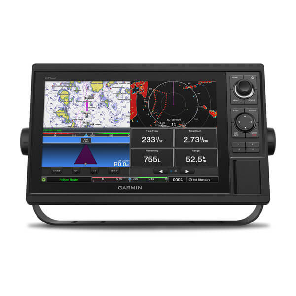
Garmin GPSMAP® 1022 10-inch Chartplotter Is All-in-1 Solution
Model: 010-01740-00
UPC: 753759168308
- 10-inch color display with keypad interface and multifunction control knob
- High-sensitivity internal 10 Hz GPS and GLONASS receiver
- Fully network capable for Garmin Marine Network and NMEA 2000® plus NMEA 0183 support
- Supports optional BlueChart® g3 Vision® premium charts
GPSMAP 1022 is designed for cruisers, sailors and sailing racers who need the advanced all-in-1 solution provided by our 10-inch keyed chartplotter. Features a large, bright screen coupled with a quick and easy-to-use keypad interface with user-programmable keys and a multifunction control knob.
Garmin Marine Network support allows sharing of sonar, maps, user data, dome or open-array radar, IP cameras and Panoptix™ sonar among multiple units. Includes NMEA 2000 network connectivity and NMEA 0183 support for autopilots, digital switching, weather, FUSION-Link, VHF, AIS and other sensors.
Built in Wi-Fi gives you access to the free all-in-one ActiveCaptain™ app, so you can manage your marine experience from nearly anywhere. It creates a simple yet powerful connection between your compatible mobile device and your Garmin chartplotter, charts, maps and the boating community. Wherever you are, you’ll have unlimited access to your cartography, the ability to purchase new maps and charts and access to the Garmin Quickdraw™ Contours Community. Stay connected with smart notifications on your chartplotter screen. You can also plan a trip or prefish a lake, and ActiveCaptain will automatically sync with your chartplotter. Even get notifications for software updates, and decide when to download them on your device.
Fast, responsive built-in 10 Hz GPS and GLONASS receiver refreshes your position and heading 10 times each second to make your movement on the screen more fluid. It makes dropping up to 5,000 accurate waypoints — and finding your way back to them — quick and easy.
Upgrade to optional premium BlueChart g3 Vision charts and LakeVü g3 Ultra maps. These add features such as high-resolution relief shading of bottom structure — which provides more 3-D relief than contours alone — satellite imagery and more.
To help you gain a wind-maximizing competitive edge, your chartplotter features a pre-race guidance page that shows your virtual starting line along with data fields showing laylines, time to burn before the start and a race timer that can be synchronized across all your networked Garmin GPS products. In addition, other supported sailing features include an enhanced wind rose, heading and course-over-ground lines, set and drift, true and apparent wind data and more.
If you have waypoints, tracks or frequently used routes stored on another manufacturer’s GPS product — or on a Garmin handheld device — it’s easy to transfer those items to your new Garmin chartplotter via industry-standard GPX software formatting.
Specifications
| Performance and Physical | |
| Dimensions | 12.5″ x 7.3″ x 2.7″ (318 x 185 x 69 cm) |
| Display size | 8.8″ x 4.9″ (224 x 125 cm) |
| Display resolution | 1024 x 600 |
| Display type | WSVGA display |
| Weight | 4.1lbs |
| Water rating | IPX7 |
| Power consumption | Max power usage at 10 Vdc: 32.4 W |
| Antenna | Internal or external over NMEA 2000 |
| Mounting options | Bail or flush |
| Receiver | 10 Hz high-sensitivity |
| Garmin Marine Network™ ports | 2 |
| Preloaded maps | None |
| Accepts data cards | 2 SD™ cards |
| Waypoints | 5,000 |
| Routes | 100 |
| Track log | 50,000 points; 50 saved tracks |
| Tide tables | Yes |
| Garmin Radar compatible | Yes |
| Garmin Sonar compatible | Yes (with external black box, sold separately) |
| Garmin SmartMode compatible (customizable monitor presets) | Yes |
| Supports AIS (tracks target ships position) | Yes |
| Supports DSC (displays position data from DSC-capable VHF radio) | Yes |
| Garmin Meteor™ Audio System compatible | Yes |
| Supports FUSION-Link™ compatible radios | Yes |
| GSD™ Black Box sonar support | Yes |
| GCV™ Black Box sonar support | Yes |
| ActiveCaptain compatible | Yes |
| Garmin Helm compatible | Yes |
| GRID™ (Garmin Remote Input Device) compatible | Yes |
| Wireless remote compatible | Yes |
| CHIRP sonar technology | Yes (with external black box, sold separately) |
| ClearVü | Yes (with external black box, sold separately) |
| SideVü | Yes (with external black box, sold separately) |
| NMEA 2000® compatible | Yes |
| NMEA 0183 input ports | 1 |
| NMEA 0183 output ports | 1 |
| Video input ports | 1 BNC |
| Video output ports | None |
| Wireless connectivity | Yes |
What’s in the Box:
- GPSMAP 1022 chartplotter
- Power/data cable
- NMEA 2000 T-connector
- NMEA 2000 drop cable (2 m)
- Bail mount kit with knobs
- Flush mount kit with gasket
- Protective cover
- Trim piece snap covers
- Documentation
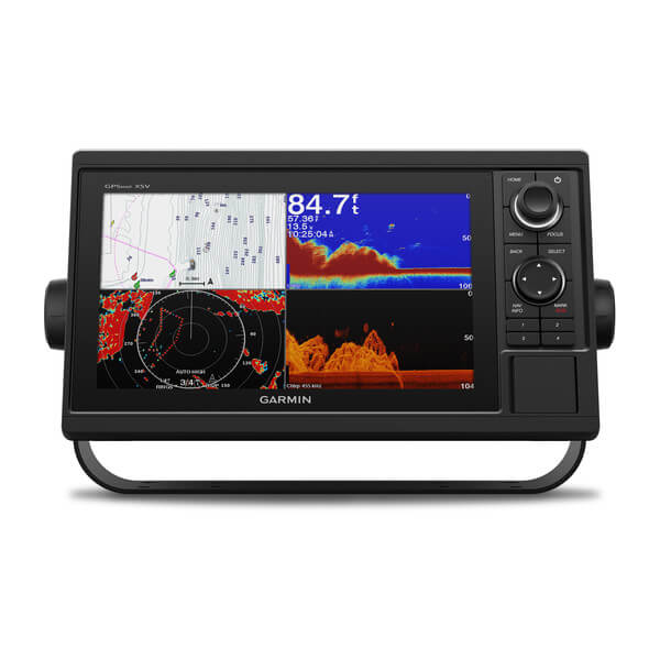
Garmin GPSMAP® 1022xsv 10-inch 10-inch Chartplotter/Sonar Combo Is All-in-1 Solution
Model: 010-01740-02
UPC: 753759168315
- 10-inch color display with keypad interface and multifunction control knob
- High-sensitivity internal 10 Hz GPS and GLONASS receiver
- Built-in single channel CHIRP sonar, CHIRP ClearVü and CHIRP SideVü scanning sonar and Panoptix™ support (transducers sold separately)
- Fully network capable for Garmin Marine Network and NMEA 2000® plus NMEA 0183 support
- Supports optional BlueChart® g3 Vision® premium charts
Experience an advanced all-in-1 solution with our 10-inch GPSMAP 1022xsv keyed combo. comes with or without a transducer for Garmin CHIRP sonar, CHIRP ClearVü and CHIRP SideVü. It also has built-in support for Panoptix all-seeing sonar and premium Garmin sonar modules (transducers sold separately). Features a large, bright screen coupled with a quick and easy-to-use keypad interface with user-programmable keys and a multifunction control knob.
Garmin Marine Network support allows sharing of sonar, maps, user data, dome or open-array radar, IP cameras and Panoptix™ sonar among multiple units. Includes NMEA 2000 network connectivity and NMEA 0183 support for autopilots, digital switching, weather, FUSION-Link, VHF, AIS and other sensors.
Enjoy built-in ANT wireless connectivity directly to quatix® marine watch, Garmin Nautix™ in-view display, gWind™ Wireless 2 transducer, GNX™ Wind marine instrument and wireless remote controls.
Built in Wi-Fi gives you access to the free all-in-one ActiveCaptain™ app, so you can manage your marine experience from nearly anywhere. It creates a simple yet powerful connection between your compatible mobile device and your Garmin chartplotter, charts, maps and the boating community. Wherever you are, you’ll have unlimited access to your cartography, the ability to purchase new maps and charts and access to the Garmin Quickdraw™ Contours Community. Stay connected with smart notifications on your chartplotter screen. You can also plan a trip or prefish a lake, and ActiveCaptain will automatically sync with your chartplotter. Even get notifications for software updates, and decide when to download them on your device.
Right out of the box, you have access to some amazing sonar capabilities; all you have to add are transducers. Comes with built-in Garmin 1 kW CHIRP sonar, CHIRP ClearVü and CHIRP SideVü scanning sonar. It even supports Panoptix all-seeing sonar, premium Garmin sonar modules and a wide range of transducers (sold separately).
Networked combos can share their internal sonar with any other device on the network. You can also choose what information is overlaid on the sonar screen; for example, radar, time of day or GPS speed.
Fast, responsive built-in 10 Hz GPS and GLONASS receiver refreshes your position and heading 10 times each second to make your movement on the screen more fluid. It makes dropping up to 5,000 accurate waypoints — and finding your way back to them — quick and easy.
Upgrade to optional premium BlueChart g3 Vision charts and LakeVü g3 Ultra maps. These add features such as high-resolution relief shading of bottom structure — which provides more 3-D relief than contours alone — satellite imagery and more.
Instantly create personalized HD fishing maps on screen with 1-foot contours. Tailor them to fit your needs. These are your maps — you own them. Keep the data to yourself, or share it with the Quickdraw Community on Garmin Connect™.
To help you gain a wind-maximizing competitive edge, your chartplotter features a pre-race guidance page that shows your virtual starting line along with data fields showing laylines, time to burn before the start and a race timer that can be synchronized across all your networked Garmin GPS products. In addition, other supported sailing features include an enhanced wind rose, heading and course-over-ground lines, set and drift, true and apparent wind data and more.
If you have waypoints, tracks or frequently used routes stored on another manufacturer’s GPS product — or on a Garmin handheld device — it’s easy to transfer those items to your new Garmin chartplotter via industry-standard GPX software formatting.
Specifications
| Performance and Physical | |
| Dimensions | 12.5″ x 7.3″ x 2.7″ (318 x 185 x 69 cm) |
| Display size | 8.8″ x 4.9″ (224 x 125 cm) |
| Display resolution | 1024 x 600 |
| Display type | WSVGA display |
| Weight | 4.1lbs |
| Water rating | IPX7 |
| Power consumption | Max power usage at 10 Vdc: 32.4 W |
| Antenna | Internal or external over NMEA 2000 |
| Mounting options | Bail or flush |
| Receiver | 10 Hz high-sensitivity |
| Garmin Marine Network™ ports | 2 |
| Preloaded maps | None |
| Accepts data cards | 2 SD™ cards |
| Waypoints | 5,000 |
| Routes | 100 |
| Track log | 50,000 points; 50 saved tracks |
| Tide tables | Yes |
| Garmin Radar compatible | Yes |
| Garmin Sonar compatible | Yes (built-in) |
| Garmin SmartMode compatible (customizable monitor presets) | Yes |
| Supports AIS (tracks target ships position) | Yes |
| Supports DSC (displays position data from DSC-capable VHF radio) | Yes |
| Garmin Meteor™ Audio System compatible | Yes |
| Supports FUSION-Link™ compatible radios | Yes |
| GSD™ Black Box sonar support | Yes |
| GCV™ Black Box sonar support | Yes |
| ActiveCaptain compatible | Yes |
| Garmin Helm compatible | Yes |
| GRID™ (Garmin Remote Input Device) compatible | Yes |
| Wireless remote compatible | Yes |
| Dual-frequency (50/200 kHz) sonar capable | Yes |
| Dual-beam (77/200 kHz) sonar capable | Yes |
| Transmit power | 1 kW traditional; 1 kW CHIRP |
| CHIRP sonar technology | Yes (Built-in) |
| ClearVü | Yes with CHIRP (built-in) |
| SideVü | Yes with CHIRP (built-in) |
| Maximum depth | 5,000 ft at 1kW (depth capacity is dependent on water bottom type and other water conditions) |
| Bottom lock (shows return from the bottom up) | Yes |
| Water temperature log and graph | Yes |
| Sonar recording | Yes |
| Sonar history rewind | Yes |
| NMEA 2000® compatible | Yes |
| Transducer pin numbers | 12 |
| NMEA 0183 input ports | 1 |
| NMEA 0183 output ports | 1 |
| Video input ports | 1 BNC |
| Video output ports | None |
| Wireless connectivity | Yes |
What’s in the Box:
- GPSMAP 1022xsv chartplotter
- Power/data cable
- NMEA 2000 T-connector
- NMEA 2000 drop cable (2 m)
- Bail mount kit with knobs
- Flush mount kit with gasket
- Protective cover
- Trim piece snap covers
- Documentation
- 8-pin transducer to 12-pin sounder adapter cable
Garmin GPSMAP® 1042xsv 10-inch 10-inch Chartplotter/Sonar Combo Is All-in-1 Solution
Model: 010-01740-03
UPC: 753759168322
- 10-inch color display with keypad interface and multifunction control knob
- Built-in support for Garmin CHIRP sonar and CHIRP ClearVü and CHIRP SideVü scanning sonars (transducers sold separately)
- Preloaded BlueChart® g3 charts and LakeVü g3 maps
- High-sensitivity internal 10 Hz GPS and GLONASS receiver
- Fully network capable for Garmin Marine Network and NMEA 2000® connectivity plus NMEA 0183 support
Experience an advanced all-in-1 solution with our 10-inch GPSMAP 1042xsv keyed combo. Includes transducer for Garmin CHIRP sonar, CHIRP ClearVü and CHIRP SideVü (also available without transducer). It also has built-in support for Panoptix all-seeing sonar and premium Garmin sonar modules (transducers sold separately). Features a large, bright screen coupled with a quick and easy-to-use keypad interface with user-programmable keys and a multifunction control knob.
Garmin Marine Network support allows sharing of sonar, maps, user data, dome or open-array radar, IP cameras and Panoptix sonar among multiple units. Plust, there’s NMEA 2000 network connectivity and NMEA 0183 support for autopilots, digital switching, weather, media, VHF, AIS and other sensors.
Right out of the box, you have access to some amazing sonar capabilities; all you have to add are transducers. GPSMAP 1042xsv comes with built-in Garmin 1 kW CHIRP sonar along with CHIRP ClearVü and CHIRP SideVü scanning sonars. It even supports Panoptix all-seeing sonar, including Panoptix LiveScope and other premium Garmin sonar modules (transducers sold separately).
Networked combos can share their internal sonar with any other device on the network. You can also choose what information is overlaid on the sonar screen; for example, radar, time of day or GPS speed.
LakeVü g3 inland maps and BlueChart® g3 coastal charts provide industry-leading coverage, clarity and detail with integrated Garmin and Navionics® data and Auto Guidance1 technology. LakeVü g3 and BlueChart g3 include Auto Guidance1, which uses your desired depth and overhead clearance to calculate routes and provide a suggested path to follow. LakeVü g3 provides coverage on more than 17,000 lakes with up to 1’ contours. BlueChart g3 also includes NOAA raster cartography, available as a free downloadable feature via the ActiveCaptain® app.
Accessory map purchases, such as LakeVü g3 Ultra or BlueChart® g3 Vision, add even more features and detail to your maps and charts. LakeVü g3 Ultra and BlueChart g3 Vision add high-resolution relief shading, which provides an easy-to-interpret, clearer view of bottom structure than contour lines alone — plus many other chart and map-enhancing features.
Enjoy built-in ANT wireless connectivity directly to our quatix® marine watches, gWind™ Wireless 2 transducer, GNX™ Wind marine instrument and wireless remote controls. You can even stream and control a VIRB® action camera from the chartplotter.
Built in Wi-Fi® connectivity gives you access to the free all-in-one ActiveCaptain® app, so you can manage your marine experience from nearly anywhere. It creates a simple yet powerful connection between your compatible mobile device and your Garmin chartplotter, charts, maps and the boating community. Wherever you are, you’ll have unlimited access to your cartography, the ability to purchase new maps and charts and access to the Garmin Quickdraw™ Contours Community. Stay connected with smart notifications on your chartplotter screen. You can also plan a trip or prefish a lake, and ActiveCaptain will automatically sync with your chartplotter. Even get notifications for software updates, and decide when to download them on your device.
Fast, responsive built-in 10 Hz GPS and GLONASS refreshes your position and heading 10 times each second to make your movement on the screen more fluid. It makes dropping up to 5,000 accurate waypoints — and finding your way back to them — quick and easy.
Instantly create personalized HD fishing maps on screen with 1’ contours. Tailor them to fit your needs. These are your maps — you own them. Keep the data to yourself, or share it with the Quickdraw Community on our Garmin Connect™ online network.
To help you gain a wind-maximizing competitive edge, your chartplotter features a prerace guidance page that shows your virtual starting line along with data fields showing laylines, time to burn before the start and a race timer that can be synchronized across all your networked Garmin GPS products. In addition, other supported sailing features include an enhanced wind rose, heading and course-over-ground lines, set and drift, true and apparent wind data and more.
If you have waypoints, tracks or frequently used routes stored on another manufacturer’s GPS product — or on a Garmin handheld device — it’s easy to transfer those items to your new Garmin chartplotter via industry-standard GPX software formatting.
Specifications
| Performance and Physical | |
| Dimensions | 12.5″ x 7.3″ x 2.7″ (318 x 185 x 69 cm) |
| Display size | 8.8″ x 4.9″ (224 x 125 cm) |
| Display resolution | 1024 x 600 |
| Display type | WSVGA display |
| Weight | 4.1lbs |
| Water rating | IPX7 |
| Power consumption | Max power usage at 10 Vdc: 32.4 W |
| Antenna | Internal or external over NMEA 2000 |
| Mounting options | Bail or flush |
| Receiver | 10 Hz high-sensitivity |
| Garmin Marine Network™ ports | 2 |
| Preloaded maps | BlueChart® g3 (coastal maps) and LakeVü g3 (inland maps) |
| Accepts data cards | 2 SD™ cards |
| Waypoints | 5,000 |
| Routes | 100 |
| Track log | 50,000 points; 50 saved tracks |
| Tide tables | Yes |
| Garmin Radar compatible | Yes |
| Garmin Sonar compatible | Yes (built-in) |
| Garmin SmartMode compatible (customizable monitor presets) | Yes |
| Supports AIS (tracks target ships position) | Yes |
| Supports DSC (displays position data from DSC-capable VHF radio) | Yes |
| Garmin Meteor™ Audio System compatible | Yes |
| Supports FUSION-Link™ compatible radios | Yes |
| GSD™ Black Box sonar support | Yes |
| GCV™ Black Box sonar support | Yes |
| ActiveCaptain compatible | Yes |
| Garmin Helm compatible | Yes |
| GRID™ (Garmin Remote Input Device) compatible | Yes |
| Wireless remote compatible | Yes |
| Dual-frequency (50/200 kHz) sonar capable | Yes |
| Dual-beam (77/200 kHz) sonar capable | Yes |
| Transmit power | 1 kW traditional; 1 kW single channel CHIRP |
| CHIRP sonar technology | Yes (Built-in) |
| ClearVü | Yes with CHIRP (built-in) |
| SideVü | Yes with CHIRP (built-in) |
| Maximum depth | 5,000 ft at 1kW (depth capacity is dependent on water bottom type and other water conditions) |
| Bottom lock (shows return from the bottom up) | Yes |
| Water temperature log and graph | Yes |
| Sonar recording | Yes |
| Sonar history rewind | Yes |
| NMEA 2000® compatible | Yes |
| Transducer pin numbers | 12 |
| NMEA 0183 input ports | 1 |
| Video input ports | 1 BNC |
| Video output ports | None |
| Wireless connectivity | Yes |
What’s in the Box:
- GPSMAP 1042xsv chartplotter
- Power/data cable
- NMEA 2000 T-connector
- NMEA 2000 drop cable (2 m)
- Bail mount kit with knobs
- Flush mount kit with gasket
- Protective cover
- Trim piece snap covers
- Documentation
- 8-pin transducer to 12-pin sounder adapter cable
Garmin GPSMAP® 1222 12-inch Chartplotter Is All-in-1 Solution
Model: 010-01741-00
UPC: 753759168339
- 12-inch color display with keypad interface and multifunction control knob
- High-sensitivity internal 10 Hz GPS and GLONASS receiver
- Fully network capable for Garmin Marine Network and NMEA 2000® plus NMEA 0183 support
- Supports optional BlueChart® g2 Vision® HD charts for Auto Guidance and other premium navigation features
GPSMAP 1222 is designed for cruisers, sailors and sailing racers who need the advanced all-in-1 solution provided by our 10-inch keyed chartplotter. Features a large, bright screen coupled with a quick and easy-to-use keypad interface with user-programmable keys and a multifunction control knob.
Garmin Marine Network support allows sharing of sonar, maps, user data, dome or open-array radar, IP cameras and Panoptix™ sonar among multiple units. Includes NMEA 2000 network connectivity and NMEA 0183 support for autopilots, digital switching, weather, FUSION-Link, VHF, AIS and other sensors.
Enjoy built-in Wi-Fi connectivity for BlueChart Mobile 2.0 and Garmin Helm apps. Garmin Helm allows you to view and control your compatible chartplotter from a compatible smartphone or tablet while providing enhanced situational awareness for the mariner. With BlueChart Mobile, a free app downloaded from the App Store™, you can get reliable weather information while you plan marine routes on your iPad® or iPhone® then wirelessly transfer them to your boat’s compatible networked Garmin chartplotter. You can even stream and control a VIRB action camera from the chartplotter.
Enjoy built-in ANT wireless connectivity directly to quatix® marine watch, Garmin Nautix™ in-view display, gWind™ Wireless 2 transducer, GNX™ Wind marine instrument and wireless remote controls.
Fast, responsive built-in 10 Hz GPS and GLONASS receiver refreshes your position and heading 10 times each second to make your movement on the screen more fluid. It makes dropping up to 5,000 accurate waypoints — and finding your way back to them — quick and easy.
Two SD™ card slots provide expandable memory for accessory map purchases, such as LakeVü HD, LakeVü HD Ultra, BlueChart® g2 HD or BlueChart® g2 Vision® HD, which adds Garmin patented Auto Guidance and other great features.
To help you gain a wind-maximizing competitive edge, your chartplotter features a pre-race guidance page that shows your virtual starting line along with data fields showing laylines, time to burn before the start and a race timer that can be synchronized across all your networked Garmin GPS products. In addition, other supported sailing features include an enhanced wind rose, heading and course-over-ground lines, set and drift, true and apparent wind data and more.
If you have waypoints, tracks or frequently used routes stored on another manufacturer’s GPS product — or on a Garmin handheld device — it’s easy to transfer those items to your new Garmin chartplotter via industry-standard GPX software formatting.
1Auto Guidance is for planning purposes only and does not replace safe navigation operations.
Specifications
| Performance and Physical | |
| Dimensions | 14.1″ x 8.9″ x 2.7″ (35.8 x 22.6 x 6.9 cm) |
| Display size | 10.3″ x 6.4″ (26.2 x 16.3 cm) |
| Display resolution | 1280 x 800 |
| Display type | WXGA display |
| Weight | 5.2 lbs |
| Water rating | IPX7 |
| Antenna | Internal or external over NMEA 2000 |
| NMEA 2000® compatible | Yes |
| NMEA 0183 compatible | Yes |
| SiriusXM™ Weather & Radio compatible | Yes |
| Power consumption | Max power usage at 10 Vdc: 34.8 W Typical current draw at 12 Vdc: 2.2 A Max current draw at 12 Vdc: 2.9 A |
| Mounting options | Bail or flush |
| Maps and Memory | |
| Preloaded maps | None |
| Accepts data card | 2 SD™ cards |
| Waypoints | 5,000 |
| Routes | 100 |
| Track log | 50,000 points; 50 saved tracks |
| Outdoor Recreation Features | |
| Tide tables | Yes |
| Chartplotter Features | |
| Garmin Radar compatible | Yes |
| Garmin Sonar compatible | Yes (with external black box, sold separately) |
| Garmin SmartMode compatible (customizable monitor presets) | Yes |
| Supports AIS (tracks target ships position) | Yes |
| Supports DSC (displays position data from DSC-capable VHF radio) | Yes |
| Garmin Meteor™ Audio System compatible | Yes |
| Supports FUSION-Link™ compatible radios | Yes |
| GSD™ Black Box sonar support | Yes |
| GCV™ Black Box sonar support | Yes |
| ActiveCaptain compatible | Yes |
| Garmin Helm compatible | Yes |
| GRID™ (Garmin Remote Input Device) compatible | Yes |
| Wireless remote compatible | Yes |
| Sonar Features & Specifications | |
| CHIRP sonar technology | Yes (with external black box, sold separately) |
| ClearVü | Yes (with external black box, sold separately) |
| SideVü | Yes (with external black box, sold separately) |
| Connections | |
| NMEA 2000® compatible | Yes |
| NMEA 0183 input ports | 1 |
| NMEA 0183 output ports | 1 |
| Video input ports | 1 BNC |
| Video output ports | None |
| Wireless connectivity | Yes |
What’s in the Box:
- GPSMAP 1222 chartplotter
- Power/data cable
- NMEA 2000 T-connector
- NMEA 2000 drop cable (2 m)
- Bail mount kit with knobs
- Flush mount kit with gasket
- Protective cover
- Trim piece snap covers
- Documentation
Garmin GPSMAP® 1222xsv 12-inch Chartplotter/Sonar Combo Is All-in-1 Solution
Model: 010-01741-02
UPC: 753759168346
- 12-inch color display with keypad interface and multifunction control knob
- High-sensitivity internal 10 Hz GPS and GLONASS receiver
- Built-in single channel CHIRP sonar, CHIRP ClearVü and CHIRP SideVü scanning sonar and Panoptix™ support (transducers sold separately)
- Fully network capable for Garmin Marine Network and NMEA 2000® plus NMEA 0183 support
Experience an advanced all-in-1 solution with our 12-inch GPSMAP 1222xsv keyed combo. It has built-in support for Garmin CHIRP sonar, CHIRP ClearVü, CHIRP SideVü. It also has built-in support for Panoptix all-seeing sonar and premium Garmin sonar modules (transducers sold separately). Features a large, bright screen coupled with a quick and easy-to-use keypad interface with user-programmable keys and a multifunction control knob.
Garmin Marine Network support allows sharing of sonar, maps, user data, dome or open-array radar, IP cameras and Panoptix™ sonar among multiple units. Includes NMEA 2000 network connectivity and NMEA 0183 support for autopilots, digital switching, weather, FUSION-Link, VHF, AIS and other sensors.
Enjoy built-in ANT wireless connectivity directly to quatix® marine watch, Garmin Nautix™ in-view display, gWind™ Wireless 2 transducer, GNX™ Wind marine instrument and wireless remote controls.
Built in Wi-Fi gives you access to the free all-in-one ActiveCaptain™ app, so you can manage your marine experience from nearly anywhere. It creates a simple yet powerful connection between your compatible mobile device and your Garmin chartplotter, charts, maps and the boating community. Wherever you are, you’ll have unlimited access to your cartography, the ability to purchase new maps and charts and access to the Garmin Quickdraw™ Contours Community. Stay connected with smart notifications on your chartplotter screen. You can also plan a trip or prefish a lake, and ActiveCaptain will automatically sync with your chartplotter. Even get notifications for software updates, and decide when to download them on your device.
Right out of the box, you have access to some amazing sonar capabilities; all you have to add are transducers. Comes with built-in Garmin 1 kW CHIRP sonar, CHIRP ClearVü and CHIRP SideVü scanning sonar. It even supports Panoptix all-seeing sonar, premium Garmin sonar modules and a wide range of transducers (sold separately).
Networked combos can share their internal sonar with any other device on the network. You can also choose what information is overlaid on the sonar screen; for example, radar, time of day or GPS speed.
Fast, responsive built-in 10 Hz GPS and GLONASS receiver refreshes your position and heading 10 times each second to make your movement on the screen more fluid. It makes dropping up to 5,000 accurate waypoints — and finding your way back to them — quick and easy.
Two SD™ card slots provide expandable memory for accessory map purchases, such as LakeVü HD, LakeVü HD Ultra, BlueChart® g2 HD or BlueChart® g2 Vision® HD, which adds Garmin patented Auto Guidance and other great features.
Instantly create personalized HD fishing maps on screen with 1-foot contours. Tailor them to fit your needs. These are your maps — you own them. Keep the data to yourself, or share it with the Quickdraw Community on Garmin Connect™.
To help you gain a wind-maximizing competitive edge, your chartplotter features a pre-race guidance page that shows your virtual starting line along with data fields showing laylines, time to burn before the start and a race timer that can be synchronized across all your networked Garmin GPS products. In addition, other supported sailing features include an enhanced wind rose, heading and course-over-ground lines, set and drift, true and apparent wind data and more.
If you have waypoints, tracks or frequently used routes stored on another manufacturer’s GPS product — or on a Garmin handheld device — it’s easy to transfer those items to your new Garmin chartplotter via industry-standard GPX software formatting.
Specifications
| Performance and Physical | |
| Dimensions | 14.1″ x 8.9″ x 2.7″ (35.8 x 22.6 x 6.9 cm) |
| Display size | 10.3″ x 6.4″ (26.2 x 16.3 cm) |
| Display resolution | 1280 x 800 |
| Display type | WXGA display |
| Weight | 5.2 lbs |
| Water rating | IPX7 |
| Antenna | Internal or external over NMEA 2000 |
| NMEA 2000® compatible | Yes |
| NMEA 0183 compatible | Yes |
| SiriusXM™ Weather & Radio compatible | Yes |
| Power consumption | Max power usage at 10 Vdc: 34.8 W Typical current draw at 12 Vdc: 2.2 A Max current draw at 12 Vdc: 2.9 A |
| Mounting options | Bail or flush |
| Maps and Memory | |
| Preloaded maps | None |
| Accepts data card | 2 SD™ cards |
| Waypoints | 5,000 |
| Routes | 100 |
| Track log | 50,000 points; 50 saved tracks |
| Chartplotter Features | |
| Garmin Radar compatible | Yes |
| Garmin Sonar compatible | Yes (with external black box, sold separately) |
| Wireless remote compatible | Yes |
| Supports AIS (tracks target ships position) | Yes |
| Supports DSC (displays position data from DSC-capable VHF radio) | Yes |
| Tide tables | Yes |
| Garmin Meteor Audio System compatible | Yes |
| Supports Fusion Lync compatible marine radios | Yes |
| GSD™ Black Box sonar support | Yes |
| GCV™ Black Box sonar support | Yes |
| BlueChart® Mobile (planning) compatible | Yes |
| Garmin Helm compatible | Yes |
| GRID™ (Garmin Remote Input Device) compatible | Yes |
| Connections | |
| Transducer | 1 – 12 pin |
| NMEA 0183 input ports | 1 |
| NMEA 0183 output ports | 1 |
| Video input ports | 1 BNC |
| Video output ports | None |
| Wireless connectivity | Yes |
| Garmin Marine Network™ ports | 2 |
| Sonar Features and Specifications | |
| CHIRP sonar technology | Yes (Built-in) |
| ClearVü | Yes with CHIRP (built-in) |
| SideVü | Yes with CHIRP (built-in) |
| Dual-frequency (50/200 kHz) sonar capable | Yes |
| Dual-beam (77/200 kHz) sonar capable | Yes |
| Frequencies supported | Traditional: 50/77/83/200 kHz CHIRP (low, medium, high) ClearVü/SideVü (260/455/800 kHz) (dependent on transducer) |
| Transmit power | 1 kW traditional; 1 kW CHIRP |
| Maximum depth | 5,000 ft at 1kW (depth capacity is dependent on water bottom type and other water conditions) |
| Bottom lock (shows return from the bottom up) | Yes |
| Water temperature log and graph | Yes |
| Sonar recording | Yes |
| Sonar history rewind | Yes |
What’s in the Box:
- GPSMAP 1222xsv chartplotter
- Power/data cable
- NMEA 2000 T-connector
- NMEA 2000 drop cable (2 m)
- Bail mount kit with knobs
- Flush mount kit with gasket
- Protective cover
- Trim piece snap covers
- Documentation
- 8-pin transducer to 12-pin sounder adapter cable
Model: 010-02590-01
- Easy-to-use keyed 5″ chartplotter with a bright, sunlight-readable screen
- Included GT20-TM transducer for Garmin traditional and ClearVü scanning sonars with vivid color palettes
- Preloaded LakeVü g3 inland maps with integrated Navionics® data cover more than 18,000 lakes with up to 1’ contours
- Supports Garmin Navionics+ and Garmin Navionics Vision+
- Built-in Wi-Fi® connectivity with compatible Garmin chartplotters to wirelessly share sonar, waypoints and routes
- Pair with the free all-in-one ActiveCaptain® app on a compatible smartphone for access to the OneChart™ feature, software updates and more
Fish like a local with the 5″ or 7″ ECHOMAP™ UHD2 chartplotters. See clear, sharp fish arches with Garmin traditional sonar. Use ClearVü scanning sonar featuring vivid color palettes for clear, high-contrast views below your boat. Know the waters you’re in as if you grew up fishing them by using built-in LakeVü g3 inland maps or BlueChart® g3 coastal charts. It also supports Garmin Navionics+ and Garmin Navionics Vision+. Use built-in Wi-Fi® connectivity to share sonar, waypoints and routes with another compatible Garmin chartplotter. You can also pair with the free all-in-one ActiveCaptain® app on a compatible smartphone for access to the OneChart™ feature, software updates and more.
What’s in the Box:
- ECHOMAP UHD2 5″ chartplotter
- GT20 transducer where noted
- power/data cable, tilt/swivel mount
- flush mount
- hardware
- documentation
Model: 010-02590-51
- Easy-to-use keyed 5″ chartplotter with a bright, sunlight-readable screen
- Included GT20-TM transducer for Garmin traditional and ClearVü™ scanning sonars
- Preloaded Garmin Navionics+™ mapping with U.S. inland content covering thousands of lakes with up to 1’ contours
Fish like a local with the 5″ or 7″ ECHOMAP™ UHD2 chartplotters. See clear, sharp fish arches with Garmin traditional sonar. Use ClearVü™ scanning sonar featuring vivid color palettes for clear, high-contrast views below your boat. Know the waters you’re in as if you grew up fishing them by using built-in Garmin Navionics+™ mapping with coastal or inland content. Use built-in Wi-Fi®(Wi-Fi is a registered trademark of the Wi-Fi Alliance) connectivity to share sonar, waypoints and routes with another compatible Garmin chartplotter (sold separately). You can also pair with the free all-in-one ActiveCaptain® app on your compatible smartphone for access to the OneChart™ feature, software updates and more.
What’s in the Box:
- ECHOMAP UHD2 5″ chartplotter
- GT20-TM transducer where noted
- power/data cable
- tilt mount
- flush mount
- hardware
- documentation
Model: 010-02591-00
- Easy-to-use keyed 5″ chartplotter with a bright, sunlight-readable screen
- Preloaded BlueChart® g3 coastal charts with integrated Navionics® data
- Supports Garmin Navionics+ and Garmin Navionics Vision+
- Built-in Wi-Fi® connectivity with compatible Garmin chartplotters to wirelessly share sonar, waypoints and routes
- Pair with the free all-in-one ActiveCaptain® app on a compatible smartphone for access to the OneChart™ feature, software updates and more”
Fish like a local with the 5″ or 7″ ECHOMAP™ UHD2 chartplotters. See clear, sharp fish arches with Garmin traditional sonar. Use ClearVü scanning sonar featuring vivid color palettes for clear, high-contrast views below your boat. Know the waters you’re in as if you grew up fishing them by using built-in LakeVü g3 inland maps or BlueChart® g3 coastal charts. It also supports Garmin Navionics+ and Garmin Navionics Vision+. Use built-in Wi-Fi® connectivity to share sonar, waypoints and routes with another compatible Garmin chartplotter. You can also pair with the free all-in-one ActiveCaptain® app on a compatible smartphone for access to the OneChart™ feature, software updates and more.
What’s in the Box:
- ECHOMAP UHD2 5″ chartplotter
- Documentation
- power/data cable
- tilt/swivel mount
- flush mount
- hardware
Model: 010-02591-01
- Easy-to-use keyed 5″ chartplotter with a bright, sunlight-readable screen
- Preloaded BlueChart® g3 coastal charts with integrated Navionics® data
- Supports Garmin Navionics+ and Garmin Navionics Vision+
- Built-in Wi-Fi® connectivity with compatible Garmin chartplotters to wirelessly share sonar, waypoints and routes
- Pair with the free all-in-one ActiveCaptain® app on a compatible smartphone for access to the OneChart™ feature, software updates and more”
Fish like a local with the 5″ or 7″ ECHOMAP™ UHD2 chartplotters. See clear, sharp fish arches with Garmin traditional sonar. Use ClearVü scanning sonar featuring vivid color palettes for clear, high-contrast views below your boat. Know the waters you’re in as if you grew up fishing them by using built-in LakeVü g3 inland maps or BlueChart® g3 coastal charts. It also supports Garmin Navionics+ and Garmin Navionics Vision+. Use built-in Wi-Fi® connectivity to share sonar, waypoints and routes with another compatible Garmin chartplotter. You can also pair with the free all-in-one ActiveCaptain® app on a compatible smartphone for access to the OneChart™ feature, software updates and more.
What’s in the Box:
- ECHOMAP UHD2 5″ chartplotter
- GT20 transducer
- power/data cable
- tilt/swivel mount
- flush mount
- hardware
- Documentation
Model: 010-02591-50
- Easy-to-use keyed 5″ chartplotter with a bright, sunlight-readable screen
- Preloaded Garmin Navionics+™ mapping with U.S. coastal content
Fish like a local with the 5″ or 7″ ECHOMAP™ UHD2 chartplotters. See clear, sharp fish arches with Garmin traditional sonar. Use ClearVü™ scanning sonar featuring vivid color palettes for clear, high-contrast views below your boat (transducer sold separately). Know the waters you’re in as if you grew up fishing them by using built-in Garmin Navionics+™ mapping with coastal or inland content. Use built-in Wi-Fi®(Wi-Fi is a registered trademark of the Wi-Fi Alliance) connectivity to share sonar, waypoints and routes with another compatible Garmin chartplotter (sold separately). You can also pair with the free all-in-one ActiveCaptain® app on your compatible smartphone for access to the OneChart™ feature, software updates and more.
What’s in the Box:
- ECHOMAP UHD2 5″ chartplotter
- power/data cable
- tilt mount
- flush mount
- hardware
- documentation
Model: 010-02591-51
- Easy-to-use keyed 5″ chartplotter with a bright, sunlight-readable screen
- Preloaded Garmin Navionics+™ mapping with U.S. coastal content
- Included GT20-TM transducer for Garmin traditional and ClearVü™ scanning sonars
Fish like a local with the 5″ or 7″ ECHOMAP™ UHD2 chartplotters. See clear, sharp fish arches with Garmin traditional sonar. Use ClearVü™ scanning sonar featuring vivid color palettes for clear, high-contrast views below your boat (transducer sold separately). Know the waters you’re in as if you grew up fishing them by using built-in Garmin Navionics+™ mapping with coastal or inland content. Use built-in Wi-Fi®(Wi-Fi is a registered trademark of the Wi-Fi Alliance) connectivity to share sonar, waypoints and routes with another compatible Garmin chartplotter (sold separately). You can also pair with the free all-in-one ActiveCaptain® app on your compatible smartphone for access to the OneChart™ feature, software updates and more.
What’s in the Box:
- ECHOMAP UHD2 5″ chartplotter
- power/data cable
- tilt mount
- flush mount
- hardware
- documentation
- GT20-TM transducer
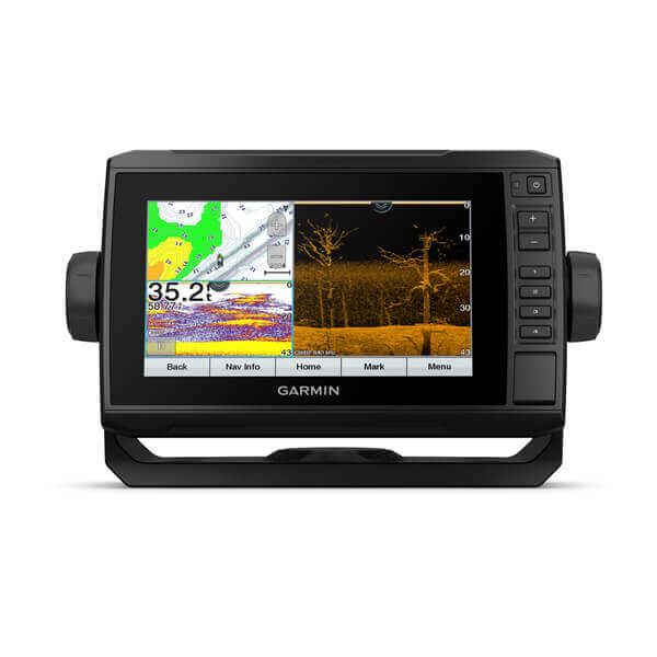
Model: 010-02679-00
- Easy-to-use 6″ chartplotter with a bright, sunlight-readable touchscreen display
- Built-in worldwide basemap with support for Garmin Navionics+™ and Garmin Navionics Vision+™ cartography, BlueChart® g3 coastal charts and LakeVü™ g3 inland maps
- Built-in Wi-Fi® connectivity lets you wirelessly share sonar, waypoints and routes with another ECHOMAP UHD2 chartplotter”
The 6″ ECHOMAP™ UHD2 touchscreen with keyed-assist chartplotter knows the water better than a local. See clear, sharp fish arches with Garmin traditional sonar. ClearVü™ and SideVü™ scanning sonars(transducer sold separately) feature vivid color palettes for clear, high-contrast views all around your boat (transducer sold separately). ECHOMAP UHD2 also supports LiveScope™ sonar systems. Built-in Wi-Fi® connectivity lets you wirelessly share sonar, waypoints and routes with another ECHOMAP UHD2 chartplotter. Wherever you drop your line, get improved position accuracy, particularly in areas where signals are reflected or weak, with multi-band GPS. You can also pair with the free all-in-one ActiveCaptain® app on your compatible smartphone for access to the OneChart™ feature, software updates and more. The chartplotter supports NMEA 2000® networks to connect your compatible autopilots, digital switching, music, and more to view all on one screen.
What’s in the Box:
- ECHOMAP 62sv UHD2
- 12-pin sounder to 8-pin transducer cable
- Power cable
- Tilt/swivel mount with quick release cradle
- Protective cover
- Hardware
- Documentation
Model: 010-02679-01
- Easy-to-use 6″ chartplotter with a bright, sunlight-readable touchscreen display
- Built-in worldwide basemap with support for Garmin Navionics+™ and Garmin Navionics Vision+™ cartography, BlueChart® g3 coastal charts and LakeVü™ g3 inland maps
- Built-in Wi-Fi® connectivity lets you wirelessly share sonar, waypoints and routes with another ECHOMAP UHD2 chartplotter”
- Included GT54-TM transducer for Garmin traditional, ClearVü™ and SideVü™ scanning sonars
The 6″ ECHOMAP™ UHD2 touchscreen with keyed-assist chartplotter knows the water better than a local. See clear, sharp fish arches with Garmin traditional sonar. ClearVü™ and SideVü™ scanning sonars feature vivid color palettes for clear, high-contrast views all around your boat. ECHOMAP UHD2 also supports LiveScope™ sonar systems. Built-in Wi-Fi® connectivity lets you wirelessly share sonar, waypoints and routes with another ECHOMAP UHD2 chartplotter. Wherever you drop your line, get improved position accuracy, particularly in areas where signals are reflected or weak, with multi-band GPS. You can also pair with the free all-in-one ActiveCaptain® app on your compatible smartphone for access to the OneChart™ feature, software updates and more. The chartplotter supports NMEA 2000® networks to connect your compatible autopilots, digital switching, music, and more to view all on one screen.
What’s in the Box:
- ECHOMAP 62sv UHD2
- 12-pin sounder to 8-pin transducer cable
- Power cable
- Tilt/swivel mount with quick release cradle
- Protective cover
- Hardware
- Documentation
- GT54-TM transducer
Model: 010-02680-01
- Easy-to-use 6″ chartplotter with a bright, sunlight-readable touchscreen display
- Included GT54-TM transducer for Garmin traditional, ClearVü™ and SideVü™ scanning sonars
- Built-in Garmin Navionics+™ inland maps with integrated Navionics® data cover more than 18,000 lakes with up to 1’ contours
- Built-in Wi-Fi® connectivity lets you wirelessly share sonar, waypoints and routes with another ECHOMAP UHD2 chartplotter
- Wirelessly connects to your Force® trolling motor to create and follow routes, navigate to waypoints, control speed, check battery life and more”
The 6″ ECHOMAP™ UHD2 touchscreen with keyed-assist chartplotter knows the water better than a local. See clear, sharp fish arches with Garmin traditional sonar. ClearVü™ and SideVü™ scanning sonars feature vivid color palettes for clear, high-contrast views all around your boat. ECHOMAP UHD2 also supports LiveScope™ sonar systems. Navigate the waters with built-in Garmin Navionics+™ cartography. Built-in Wi-Fi® connectivity lets you wirelessly share sonar, waypoints and routes with another ECHOMAP UHD2 chartplotter. Wherever you drop your line, get improved position accuracy, particularly in areas where signals are reflected or weak, with multi-band GPS. You can also pair with the free all-in-one ActiveCaptain® app on your compatible smartphone for access to the OneChart™ feature, software updates and more. The chartplotter supports NMEA 2000® networks to connect your compatible autopilots, digital switching, music, and more to view all on one screen.
What’s in the Box:
- ECHOMAP UHD2 6″ chartplotter
- GT54 transducer
- power/data cable
- tilt/swivel mount
- flush mount
- protective sun cover
- hardware
- documentation
Model: 010-026810-00
- Easy-to-use 6″ chartplotter with a bright, sunlight-readable touchscreen display
- Built-in Garmin Navionics+™ coastal charts with integrated Navionics® data
- Built-in Wi-Fi® connectivity lets you wirelessly share sonar, waypoints and routes with another ECHOMAP UHD2 chartplotter
- Wirelessly connects to your Force® trolling motor to create and follow routes, navigate to waypoints, control speed, check battery life and more”
The 6″ ECHOMAP™ UHD2 touchscreen with keyed-assist chartplotter knows the water better than a local. See clear, sharp fish arches with Garmin traditional sonar. ClearVü™ and SideVü™ scanning sonars feature vivid color palettes for clear, high-contrast views all around your boat (transducer sold separately). ECHOMAP UHD2 also supports LiveScope™ sonar systems. Navigate the waters with built-in Garmin Navionics+™ cartography. Built-in Wi-Fi® connectivity lets you wirelessly share sonar, waypoints and routes with another ECHOMAP UHD2 chartplotter. Wherever you drop your line, get improved position accuracy, particularly in areas where signals are reflected or weak, with multi-band GPS. You can also pair with the free all-in-one ActiveCaptain® app on your compatible smartphone for access to the OneChart™ feature, software updates and more. The chartplotter supports NMEA 2000® networks to connect your compatible autopilots, digital switching, music, and more to view all on one screen.
What’s in the Box:
- ECHOMAP UHD2 64sc
- 12-pin sounder to 8-pin transducer cable
- Power cable
- Tilt/swivel mount with quick release cradle
- Protective cover
- Hardware
- Documentation
Model: 010-026810-01
- Easy-to-use 6″ chartplotter with a bright, sunlight-readable touchscreen display
- Built-in Garmin Navionics+™ coastal charts with integrated Navionics® data
- Built-in Wi-Fi® connectivity lets you wirelessly share sonar, waypoints and routes with another ECHOMAP UHD2 chartplotter
- Wirelessly connects to your Force® trolling motor to create and follow routes, navigate to waypoints, control speed, check battery life and more”
- Included GT54-TM transducer for Garmin traditional, ClearVü™ and SideVü™ scanning sonars
The 6″ ECHOMAP™ UHD2 touchscreen with keyed-assist chartplotter knows the water better than a local. See clear, sharp fish arches with Garmin traditional sonar. ClearVü™ and SideVü™ scanning sonars feature vivid color palettes for clear, high-contrast views all around your boat (transducer sold separately). ECHOMAP UHD2 also supports LiveScope™ sonar systems. Navigate the waters with built-in Garmin Navionics+™ cartography. Built-in Wi-Fi® connectivity lets you wirelessly share sonar, waypoints and routes with another ECHOMAP UHD2 chartplotter. Wherever you drop your line, get improved position accuracy, particularly in areas where signals are reflected or weak, with multi-band GPS. You can also pair with the free all-in-one ActiveCaptain® app on your compatible smartphone for access to the OneChart™ feature, software updates and more. The chartplotter supports NMEA 2000® networks to connect your compatible autopilots, digital switching, music, and more to view all on one screen.
What’s in the Box:
- ECHOMAP UHD2 64sc
- 12-pin sounder to 8-pin transducer cable
- Power cable
- Tilt/swivel mount with quick release cradle
- Protective cover
- Hardware
- Documentation
- GT54-TM transducer
Model: 010-02683-00
- Easy-to-use 7″ chartplotter with a bright, sunlight-readable touchscreen display
- Built-in worldwide basemap with support for Garmin Navionics+™ and Garmin Navionics Vision+™ cartography, BlueChart® g3 coastal charts and LakeVü™ g3 inland maps
- Built-in Wi-Fi® connectivity lets you wirelessly share sonar, waypoints and routes with another UHD2 chartplotter”
The 7″ ECHOMAP™ UHD2 touchscreen with keyed-assist chartplotter knows the water better than a local. See clear, sharp fish arches with Garmin traditional sonar. ClearVü™ and SideVü™ scanning sonars feature vivid color palettes for clear, high-contrast views all around your boat (transducer sold separately). ECHOMAP UHD2 also supports LiveScope™ sonar systems. Built-in Wi-Fi® connectivity lets you wirelessly share sonar, waypoints and routes with another ECHOMAP UHD2 chartplotter. Wherever you drop your line, get improved position accuracy, particularly in areas where signals are reflected or weak, with multi-band GPS. You can also pair with the free all-in-one ActiveCaptain® app on your compatible smartphone for access to the OneChart™ feature, software updates and more. The chartplotter supports NMEA 2000® networks to connect your compatible autopilots, digital switching, music, and more to view all on one screen.
What’s in the Box:
- ECHOMAP UHD2 72sv
- 12-pin sounder to 8-pin transducer cable
- Power cable
- Tilt/swivel mount with quick release cradle
- Protective cover
- Hardware
- Documentation
Model: 010-02683-01
- Easy-to-use 7″ chartplotter with a bright, sunlight-readable touchscreen display
- Built-in worldwide basemap with support for Garmin Navionics+™ and Garmin Navionics Vision+™ cartography, BlueChart® g3 coastal charts and LakeVü™ g3 inland maps
- Built-in Wi-Fi® connectivity lets you wirelessly share sonar, waypoints and routes with another UHD2 chartplotter”
- Included GT54-TM transducer for Garmin traditional, ClearVü™ and SideVü™ scanning sonars
The 7″ ECHOMAP™ UHD2 touchscreen with keyed-assist chartplotter knows the water better than a local. See clear, sharp fish arches with Garmin traditional sonar. ClearVü™ and SideVü™ scanning sonars feature vivid color palettes for clear, high-contrast views all around your boat (transducer sold separately). ECHOMAP UHD2 also supports LiveScope™ sonar systems. Built-in Wi-Fi® connectivity lets you wirelessly share sonar, waypoints and routes with another ECHOMAP UHD2 chartplotter. Wherever you drop your line, get improved position accuracy, particularly in areas where signals are reflected or weak, with multi-band GPS. You can also pair with the free all-in-one ActiveCaptain® app on your compatible smartphone for access to the OneChart™ feature, software updates and more. The chartplotter supports NMEA 2000® networks to connect your compatible autopilots, digital switching, music, and more to view all on one screen.
What’s in the Box:
- ECHOMAP UHD2 72sv
- GT54-TM transducer
- Power cable
- Tilt/swivel mount with quick release cradle
- Protective cover
- Hardware
- Documentation
Model: 010-02594-01
- Easy-to-use keyed 7″ chartplotter with a bright, sunlight-readable screen
- Included GT20-TM transducer for Garmin traditional and ClearVü scanning sonars with vivid color palettes
- Preloaded LakeVü g3 inland maps with integrated Navionics® data cover more than 18,000 lakes with up to 1’ contours
- Supports Garmin Navionics+ and Garmin Navionics Vision+
- Built-in Wi-Fi® connectivity with compatible Garmin chartplotters to wirelessly share sonar, waypoints and routes
- Pair with the free all-in-one ActiveCaptain® app on a compatible smartphone for access to the OneChart™ feature, software updates and more
Fish like a local with the 5″ or 7″ ECHOMAP™ UHD2 chartplotters. See clear, sharp fish arches with Garmin traditional sonar. Use ClearVü scanning sonar featuring vivid color palettes for clear, high-contrast views below your boat. Know the waters you’re in as if you grew up fishing them by using built-in LakeVü g3 inland maps or BlueChart® g3 coastal charts. It also supports Garmin Navionics+ and Garmin Navionics Vision+. Use built-in Wi-Fi® connectivity to share sonar, waypoints and routes with another compatible Garmin chartplotter. You can also pair with the free all-in-one ActiveCaptain® app on a compatible smartphone for access to the OneChart™ feature, software updates and more.
What’s in the Box:
- ECHOMAP UHD2 7″ chartplotter
- GT20 transducer where noted
- power/data cable
- tilt/swivel mount
- flush mount
- hardware
- Documentation
Model: 010-02594-51
- Easy-to-use keyed 7″ chartplotter with a bright, sunlight-readable screen
- Included GT20-TM transducer for Garmin traditional and ClearVü™ scanning sonars
- Preloaded Garmin Navionics+™ mapping with U.S. inland content covering thousands of lakes with up to 1’ contours
Fish like a local with the 7″ ECHOMAP™ UHD2 chartplotters. See clear, sharp fish arches with Garmin traditional sonar. Use ClearVü™ scanning sonar featuring vivid color palettes for clear, high-contrast views below your boat. Know the waters you’re in as if you grew up fishing them by using built-in Garmin Navionics+™ mapping with coastal or inland content. Use built-in Wi-Fi®(Wi-Fi is a registered trademark of the Wi-Fi Alliance) connectivity to share sonar, waypoints and routes with another compatible Garmin chartplotter (sold separately). You can also pair with the free all-in-one ActiveCaptain® app on your compatible smartphone for access to the OneChart™ feature, software updates and more.
What’s in the Box:
- ECHOMAP UHD2 7″ chartplotter
- GT20-TM transducer
- power/data cable
- tilt mount
- flush mount
- hardware
- documentation
Model: 010-02684-00
- Easy-to-use 7″ chartplotter with a bright, sunlight-readable touchscreen display
- Built-in Garmin Navionics+™ inland maps with integrated Navionics® data cover more than 18,000 lakes with up to 1’ contours
- Built-in Wi-Fi® connectivity lets you wirelessly share sonar, waypoints and routes with another ECHOMAP UHD2 chartplotter
- Wirelessly connects to your Force® trolling motor to create and follow routes, navigate to waypoints, control speed, check battery life and more”
The 7″ ECHOMAP™ UHD2 touchscreen with keyed-assist chartplotter knows the water better than a local. See clear, sharp fish arches with Garmin traditional sonar. ClearVü™ and SideVü™ scanning sonars feature vivid color palettes for clear, high-contrast views all around your boat (transducer sold separately). ECHOMAP UHD2 also supports LiveScope™ sonar systems. Navigate the waters with built-in Garmin Navionics+™ cartography. Built-in Wi-Fi® connectivity lets you wirelessly share sonar, waypoints and routes with another ECHOMAP UHD2 chartplotter. Wherever you drop your line, get improved position accuracy, particularly in areas where signals are reflected or weak, with multi-band GPS. You can also pair with the free all-in-one ActiveCaptain® app on your compatible smartphone for access to the OneChart™ feature, software updates and more. The chartplotter supports NMEA 2000® networks to connect your compatible autopilots, digital switching, music, and more to view all on one screen.
What’s in the Box:
- ECHOMAP UHD2 73sv
- 12-pin sounder to 8-pin transducer cable
- Power cable
- Tilt/swivel mount with quick release cradle
- Protective cover
- Hardware
- Documentation
Model: 010-02684-01
- Easy-to-use 7″ chartplotter with a bright, sunlight-readable touchscreen display
- Built-in Garmin Navionics+™ inland maps with integrated Navionics® data cover more than 18,000 lakes with up to 1’ contours
- Built-in Wi-Fi® connectivity lets you wirelessly share sonar, waypoints and routes with another ECHOMAP UHD2 chartplotter
- Wirelessly connects to your Force® trolling motor to create and follow routes, navigate to waypoints, control speed, check battery life and more”
- Included GT54-TM transducer for Garmin traditional, ClearVü™ and SideVü™ scanning sonars
The 7″ ECHOMAP™ UHD2 touchscreen with keyed-assist chartplotter knows the water better than a local. See clear, sharp fish arches with Garmin traditional sonar. ClearVü™ and SideVü™ scanning sonars feature vivid color palettes for clear, high-contrast views all around your boat (transducer sold separately). ECHOMAP UHD2 also supports LiveScope™ sonar systems. Navigate the waters with built-in Garmin Navionics+™ cartography. Built-in Wi-Fi® connectivity lets you wirelessly share sonar, waypoints and routes with another ECHOMAP UHD2 chartplotter. Wherever you drop your line, get improved position accuracy, particularly in areas where signals are reflected or weak, with multi-band GPS. You can also pair with the free all-in-one ActiveCaptain® app on your compatible smartphone for access to the OneChart™ feature, software updates and more. The chartplotter supports NMEA 2000® networks to connect your compatible autopilots, digital switching, music, and more to view all on one screen.
What’s in the Box:
- ECHOMAP UHD2 73sv
- GT54-TM transducer
- Power cable
- Tilt/swivel mount with quick release cradle
- Protective cover
- Hardware
- Documentation
Model: 010-02595-01
- Easy-to-use keyed 7″ chartplotter with a bright, sunlight-readable screen
- Included GT20-TM transducer for Garmin traditional and ClearVü scanning sonars with vivid color palettes
- Preloaded BlueChart® g3 coastal charts with integrated Navionics® data
- Supports Garmin Navionics+ and Garmin Navionics Vision+
- Built-in Wi-Fi® connectivity with compatible Garmin chartplotters to wirelessly share sonar, waypoints and routes
- Pair with the free all-in-one ActiveCaptain® app on a compatible smartphone for access to the OneChart™ feature, software updates and more”
Fish like a local with the 5″ or 7″ ECHOMAP™ UHD2 chartplotters. See clear, sharp fish arches with Garmin traditional sonar. Use ClearVü scanning sonar featuring vivid color palettes for clear, high-contrast views below your boat. Know the waters you’re in as if you grew up fishing them by using built-in LakeVü g3 inland maps or BlueChart® g3 coastal charts. It also supports Garmin Navionics+ and Garmin Navionics Vision+. Use built-in Wi-Fi® connectivity to share sonar, waypoints and routes with another compatible Garmin chartplotter. You can also pair with the free all-in-one ActiveCaptain® app on a compatible smartphone for access to the OneChart™ feature, software updates and more.
What’s in the Box:
- ECHOMAP UHD2 7″ chartplotter
- GT20 transducer
- power/data cable
- tilt/swivel mount
- flush mount
- hardware
- documentation
Model: 010-02595-51
- Easy-to-use keyed 7″ chartplotter with a bright, sunlight-readable screen
- Included GT20-TM transducer for Garmin traditional and ClearVü™ scanning sonars
- Preloaded Garmin Navionics+™ mapping with U.S. coastal content
Fish like a local with the 7″ ECHOMAP™ UHD2 chartplotters. See clear, sharp fish arches with Garmin traditional sonar. Use ClearVü™ scanning sonar featuring vivid color palettes for clear, high-contrast views below your boat. Know the waters you’re in as if you grew up fishing them by using built-in Garmin Navionics+™ mapping with coastal or inland content. Use built-in Wi-Fi®(Wi-Fi is a registered trademark of the Wi-Fi Alliance) connectivity to share sonar, waypoints and routes with another compatible Garmin chartplotter (sold separately). You can also pair with the free all-in-one ActiveCaptain® app on your compatible smartphone for access to the OneChart™ feature, software updates and more.
What’s in the Box:
- ECHOMAP UHD2 7″ chartplotter
- GT20-TM transducer
- power/data cable
- tilt mount
- flush mount
- hardware
- documentation
Model: 010-02685-00
- Easy-to-use 7″ chartplotter with a bright, sunlight-readable touchscreen display
- Built-in Garmin Navionics+™ coastal charts with integrated Navionics® data
- Built-in Wi-Fi® connectivity lets you wirelessly share sonar, waypoints and routes with another ECHOMAP UHD2 chartplotter
- Wirelessly connects to your Force® trolling motor to create and follow routes, navigate to waypoints, control speed, check battery life and more”
The 7″ ECHOMAP™ UHD2 touchscreen with keyed-assist chartplotter knows the water better than a local. See clear, sharp fish arches with Garmin traditional sonar. ClearVü™ and SideVü™ scanning sonars feature vivid color palettes for clear, high-contrast views all around your boat (transducer sold separately). ECHOMAP UHD2 also supports LiveScope™ sonar systems. Navigate the waters with built-in Garmin Navionics+™ cartography. Built-in Wi-Fi® connectivity lets you wirelessly share sonar, waypoints and routes with another ECHOMAP UHD2 chartplotter. Wherever you drop your line, get improved position accuracy, particularly in areas where signals are reflected or weak, with multi-band GPS. You can also pair with the free all-in-one ActiveCaptain® app on your compatible smartphone for access to the OneChart™ feature, software updates and more. The chartplotter supports NMEA 2000® networks to connect your compatible autopilots, digital switching, music, and more to view all on one screen.
What’s in the Box:
- ECHOMAP UHD2 74sv
- 12-pin sounder to 8-pin transducer cable
- Power cable
- Tilt/swivel mount with quick release cradle
- Protective cover
- Hardware
- Documentation
Model: 010-02685-01
- Easy-to-use 7″ chartplotter with a bright, sunlight-readable touchscreen display
- Built-in Garmin Navionics+™ coastal charts with integrated Navionics® data
- Built-in Wi-Fi® connectivity lets you wirelessly share sonar, waypoints and routes with another ECHOMAP UHD2 chartplotter
- Wirelessly connects to your Force® trolling motor to create and follow routes, navigate to waypoints, control speed, check battery life and more”
- Included GT54-TM transducer for Garmin traditional, ClearVü™ and SideVü™ scanning sonars
The 7″ ECHOMAP™ UHD2 touchscreen with keyed-assist chartplotter knows the water better than a local. See clear, sharp fish arches with Garmin traditional sonar. ClearVü™ and SideVü™ scanning sonars feature vivid color palettes for clear, high-contrast views all around your boat (transducer sold separately). ECHOMAP UHD2 also supports LiveScope™ sonar systems. Navigate the waters with built-in Garmin Navionics+™ cartography. Built-in Wi-Fi® connectivity lets you wirelessly share sonar, waypoints and routes with another ECHOMAP UHD2 chartplotter. Wherever you drop your line, get improved position accuracy, particularly in areas where signals are reflected or weak, with multi-band GPS. You can also pair with the free all-in-one ActiveCaptain® app on your compatible smartphone for access to the OneChart™ feature, software updates and more. The chartplotter supports NMEA 2000® networks to connect your compatible autopilots, digital switching, music, and more to view all on one screen.
What’s in the Box:
- ECHOMAP UHD2 74sv
- GT54-TM transduce
- Power cable
- Tilt/swivel mount with quick release cradle
- Protective cover
- Hardware
- Documentation
Model: 010-02687-00
- Easy-to-use 9″ chartplotter with a bright, sunlight-readable touchscreen display with improved detail, clarity and viewing angle
- Built-in worldwide basemaps with support for Garmin Navionics+™ and Garmin Navionics Vision+™ cartography, BlueChart® g3 coastal charts and LakeVü™ g3 inland maps
- Built-in Wi-Fi® connectivity lets you wirelessly share sonar, waypoints and routes with another ECHOMAP UHD2 chartplotter”
The 9″ ECHOMAP™ UHD2 touchscreen with keyed-assist chartplotter knows the water better than a local. Its high-resolution display offers improved detail, clarity and viewing angle. See clear, sharp fish arches with Garmin traditional sonar. ClearVü™ and SideVü™ scanning sonars feature vivid color palettes for clear, high-contrast views all around your boat (transducer sold separately). ECHOMAP UDH2 also supports LiveScope™ sonar systems.Built-in Wi-Fi® connectivity lets you wirelessly share sonar, waypoints and routes with another ECHOMAP UHD2 chartplotter. Wherever you drop your line, get improved position accuracy, particularly in areas where signals are reflected or weak, with multi-band GPS. You can also pair with the free all-in-one ActiveCaptain® app on your compatible smartphone for access to the OneChart™ feature, software updates and more. The chartplotter supports NMEA 2000® networks to connect your compatible autopilots, digital switching, music, and more to view all on one screen.
What’s in the Box:
- ECHOMAP UHD2 92sv
- 12-pin sounder to 8-pin transducer cable
- Power cable
- Tilt mount with quick-release cradle
- Protective cover
- Hardware
- Documentation
Model: 010-02687-01
- Easy-to-use 9″ chartplotter with a bright, sunlight-readable touchscreen display with improved detail, clarity and viewing angle
- Built-in worldwide basemaps with support for Garmin Navionics+™ and Garmin Navionics Vision+™ cartography, BlueChart® g3 coastal charts and LakeVü™ g3 inland maps
- Built-in Wi-Fi® connectivity lets you wirelessly share sonar, waypoints and routes with another ECHOMAP UHD2 chartplotter”
- Included GT56-TM transducer for Garmin traditional, ClearVü™ and SideVü™ scanning sonars
The 9″ ECHOMAP™ UHD2 touchscreen with keyed-assist chartplotter knows the water better than a local. Its high-resolution display offers improved detail, clarity and viewing angle. See clear, sharp fish arches with Garmin traditional sonar. ClearVü™ and SideVü™ scanning sonars feature vivid color palettes for clear, high-contrast views all around your boat (transducer sold separately). ECHOMAP UDH2 also supports LiveScope™ sonar systems.Built-in Wi-Fi® connectivity lets you wirelessly share sonar, waypoints and routes with another ECHOMAP UHD2 chartplotter. Wherever you drop your line, get improved position accuracy, particularly in areas where signals are reflected or weak, with multi-band GPS. You can also pair with the free all-in-one ActiveCaptain® app on your compatible smartphone for access to the OneChart™ feature, software updates and more. The chartplotter supports NMEA 2000® networks to connect your compatible autopilots, digital switching, music, and more to view all on one screen.
What’s in the Box:
- ECHOMAP UHD2 92sv
- GT56-TM transducer
- Power cable
- Tilt mount with quick-release cradle
- Protective cover
- Hardware
- Documentation
Model: 010-02688-00
- Easy-to-use 9″ chartplotter with a bright, sunlight-readable touchscreen display with improved detail, clarity and viewing angle
- Built-in Garmin Navionics+™ inland maps with integrated Navionics® data cover more than 18,000 lakes with up to 1’ contours
- Built-in Wi-Fi® connectivity lets you wirelessly share sonar, waypoints and routes with another ECHOMAP UHD2 chartplotter
- Wirelessly connects to your Force® trolling motor to create and follow routes, navigate to waypoints, control speed, check battery life and more”
The 9″ ECHOMAP™ UHD2 touchscreen with keyed-assist chartplotter knows the water better than a local. Its high-resolution display offers improved detail, clarity and viewing angle. See clear, sharp fish arches with Garmin traditional sonar. ClearVü™ and SideVü™ scanning sonars feature vivid color palettes for clear, high-contrast views all around your boat (transducer sold separately). ECHOMAP UDH2 also supports LiveScope™ sonar systems. Navigate the waters with built-in Garmin Navionics+™ cartography. Built-in Wi-Fi® connectivity lets you wirelessly share sonar, waypoints and routes with another ECHOMAP UHD2 chartplotter. Wherever you drop your line, get improved position accuracy, particularly in areas where signals are reflected or weak, with multi-band GPS. You can also pair with the free all-in-one ActiveCaptain® app on your compatible smartphone for access to the OneChart™ feature, software updates and more. The chartplotter supports NMEA 2000® networks to connect your compatible autopilots, digital switching, music, and more to view all on one screen.
What’s in the Box:
- ECHOMAP UHD2 92sv
- 12-pin sounder to 8-pin transducer cable
- Power cable
- Tilt mount with quick-release cradle
- Protective cover
- Hardware
- Documentation
Model: 010-02688-01
- Easy-to-use 9″ chartplotter with a bright, sunlight-readable touchscreen display with improved detail, clarity and viewing angle
- Built-in Garmin Navionics+™ inland maps with integrated Navionics® data cover more than 18,000 lakes with up to 1’ contours
- Built-in Wi-Fi® connectivity lets you wirelessly share sonar, waypoints and routes with another ECHOMAP UHD2 chartplotter
- Wirelessly connects to your Force® trolling motor to create and follow routes, navigate to waypoints, control speed, check battery life and more”
- Included GT56-TM transducer for Garmin traditional, ClearVü™ and SideVü™ scanning sonars
The 9″ ECHOMAP™ UHD2 touchscreen with keyed-assist chartplotter knows the water better than a local. Its high-resolution display offers improved detail, clarity and viewing angle. See clear, sharp fish arches with Garmin traditional sonar. ClearVü™ and SideVü™ scanning sonars feature vivid color palettes for clear, high-contrast views all around your boat (transducer sold separately). ECHOMAP UDH2 also supports LiveScope™ sonar systems. Navigate the waters with built-in Garmin Navionics+™ cartography. Built-in Wi-Fi® connectivity lets you wirelessly share sonar, waypoints and routes with another ECHOMAP UHD2 chartplotter. Wherever you drop your line, get improved position accuracy, particularly in areas where signals are reflected or weak, with multi-band GPS. You can also pair with the free all-in-one ActiveCaptain® app on your compatible smartphone for access to the OneChart™ feature, software updates and more. The chartplotter supports NMEA 2000® networks to connect your compatible autopilots, digital switching, music, and more to view all on one screen.
What’s in the Box:
- ECHOMAP UHD2 92sv
- GT56 transducer
- Power cable
- Tilt mount with quick-release cradle
- Protective cover
- Hardware
- Documentation
Model: 010-02689-00
- Easy-to-use 9″ chartplotter with a bright, sunlight-readable touchscreen display with improved detail, clarity and viewing angle
- Built-in Garmin Navionics+™ coastal charts with integrated Navionics® data
- Built-in Wi-Fi® connectivity lets you wirelessly share sonar, waypoints and routes with another ECHOMAP UHD2 chartplotter
- Wirelessly connects to your Force® trolling motor to create and follow routes, navigate to waypoints, control speed, check battery life and more”
The 9″ ECHOMAP™ UHD2 touchscreen with keyed-assist chartplotter knows the water better than a local. Its high-resolution display offers improved detail, clarity and viewing angle. See clear, sharp fish arches with Garmin traditional sonar. ClearVü™ and SideVü™ scanning sonars feature vivid color palettes for clear, high-contrast views all around your boat (transducer sold separately). ECHOMAP UDH2 also supports LiveScope™ sonar systems. Navigate the waters with built-in Garmin Navionics+™ cartography. Built-in Wi-Fi® connectivity lets you wirelessly share sonar, waypoints and routes with another ECHOMAP UHD2 chartplotter. Wherever you drop your line, get improved position accuracy, particularly in areas where signals are reflected or weak, with multi-band GPS. You can also pair with the free all-in-one ActiveCaptain® app on your compatible smartphone for access to the OneChart™ feature, software updates and more. The chartplotter supports NMEA 2000® networks to connect your compatible autopilots, digital switching, music, and more to view all on one screen.
What’s in the Box:
- ECHOMAP UHD2 94sv
- 12-pin sounder to 8-pin transducer cable
- Power cable
- Tilt mount with quick-release cradle
- Protective cover
- Hardware
- Documentation
Model: 010-02689-01
- Easy-to-use 9″ chartplotter with a bright, sunlight-readable touchscreen display with improved detail, clarity and viewing angle
- Built-in Garmin Navionics+™ coastal charts with integrated Navionics® data
- Built-in Wi-Fi® connectivity lets you wirelessly share sonar, waypoints and routes with another ECHOMAP UHD2 chartplotter
- Wirelessly connects to your Force® trolling motor to create and follow routes, navigate to waypoints, control speed, check battery life and more”
- Included GT56-TM transducer for Garmin traditional, ClearVü™ and SideVü™ scanning sonars
The 9″ ECHOMAP™ UHD2 touchscreen with keyed-assist chartplotter knows the water better than a local. Its high-resolution display offers improved detail, clarity and viewing angle. See clear, sharp fish arches with Garmin traditional sonar. ClearVü™ and SideVü™ scanning sonars feature vivid color palettes for clear, high-contrast views all around your boat (transducer sold separately). ECHOMAP UDH2 also supports LiveScope™ sonar systems. Navigate the waters with built-in Garmin Navionics+™ cartography. Built-in Wi-Fi® connectivity lets you wirelessly share sonar, waypoints and routes with another ECHOMAP UHD2 chartplotter. Wherever you drop your line, get improved position accuracy, particularly in areas where signals are reflected or weak, with multi-band GPS. You can also pair with the free all-in-one ActiveCaptain® app on your compatible smartphone for access to the OneChart™ feature, software updates and more. The chartplotter supports NMEA 2000® networks to connect your compatible autopilots, digital switching, music, and more to view all on one screen.
What’s in the Box:
- ECHOMAP UHD2 94sv
- GT56-TM transducer
- Power cable
- Tilt mount with quick-release cradle
- Protective cover
- Hardware
- Documentation

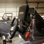
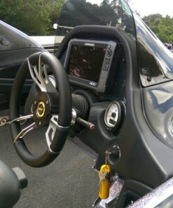
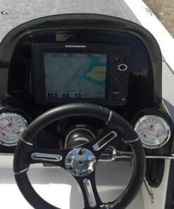
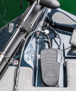
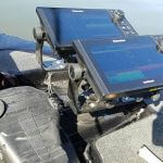


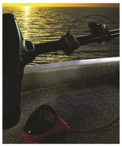
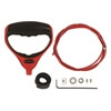
Mike Hummel –
Picked up my livescope bundle and this thing is off the charts amazing. Track your lure and track your fish. This particular bundle was perfect for what I was looking for when it came to a live scope bundle. 1022 Maps paired with a livescope has equals endless results. One of my favorite purchases to date with Crossed industries. Amazing pricing and fast shipping has kept me coming back.