


- Up to 1’ contours provide a more accurate depiction of the bottom structure for improved fishing charts and navigation in swamps, canals and marinas
- NOAA raster cartography is available as a free downloadable feature via the ActiveCaptain® app
BlueChart g3 coastal charts provide industry-leading coverage, clarity and detail with integrated Garmin and Navionics data. Also included is Auto Guidance1 technology, which uses your desired depth and overhead clearance to calculate routes and provide a suggested path to follow — overlaid onto your chart. NOAA raster cartography is also available as a free downloadable feature via the ActiveCaptain app. It gives your chartplotter paper chartlike views of NOAA-surveyed areas in which individual points of interest are labeled with corresponding longitude and latitude information. Worldwide coverage is available by regions as accessory cards or via download; each region is sold separately.
Auto Guidance Technology
The Auto Guidance feature¹ calculates a suggested route using your desired depth and overhead clearance.
Depth Range Shading
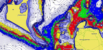
This feature displays high-resolution Depth Range Shading for up to 10 depth ranges so you can view your designated target depth.
Detailed Contours
BlueChart g3 charts feature 1’ contours that provide a more accurate depiction of bottom structure for improved fishing charts and enhanced detail in swamps, canals and port plans.
Shallow Water Shading
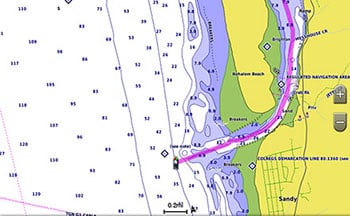
To aid in navigation, Shallow Water Shading allows map shading at a user-defined depth to give a clear picture of shallow waters to avoid.
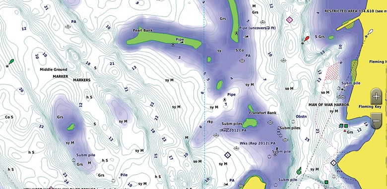
NOAA Raster Cartography
This feature gives your chartplotter paper chartlike views of NOAA-surveyed areas in which points of interest are labeled with corresponding longitude and latitude information.
¹Auto Guidance is for planning purposes only and does not replace safe navigation practices. Auto Guidance is not included in preloaded BlueChart g3 for ECHOMAP™ Plus series chartplotters
Model: 010-C1018-20
- Provides industry-leading coverage, clarity and detail with updated coastal charts that feature integrated Garmin and Navionics® data
- Auto Guidance technology calculates a route using your desired depth and overhead clearance and provides a suggested path to follow
- Includes Depth Range Shading for up to 10 depth ranges, enabling you to view your target depth at a glance
- Up to 1’ contours provide a more accurate depiction of the bottom structure for improved fishing charts and navigation in swamps, canals and marinas
- NOAA raster cartography is available as a free downloadable feature via the ActiveCaptain® app
BlueChart g3 coastal charts provide industry-leading coverage, clarity and detail with integrated Garmin and Navionics data. Also included is Auto Guidance technology, which uses your desired depth and overhead clearance to calculate routes and provide a suggested path to follow — overlaid onto your chart. NOAA raster cartography is also available as a free downloadable feature via the ActiveCaptain app. It gives your chartplotter paper chartlike views of NOAA-surveyed areas in which individual points of interest are labeled with corresponding longitude and latitude information. Worldwide coverage is available by regions as accessory cards or via download; each region is sold separately.
The Auto Guidance feature calculates a suggested route using your desired depth and overhead clearance.
This feature displays high-resolution Depth Range Shading for up to 10 depth ranges so you can view your designated target depth.
BlueChart g3 features up to 1’ contours, which provide a more accurate depiction of the bottom structure for improved fishing charts and navigation in swamps, canals and marinas.
To aid in navigation, Shallow Water Shading allows map shading at a user-defined depth to give a clear picture of shallow waters to avoid.
This feature gives your chartplotter paper chartlike views of NOAA-surveyed areas in which points of interest are labeled with corresponding longitude and latitude information.
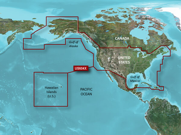
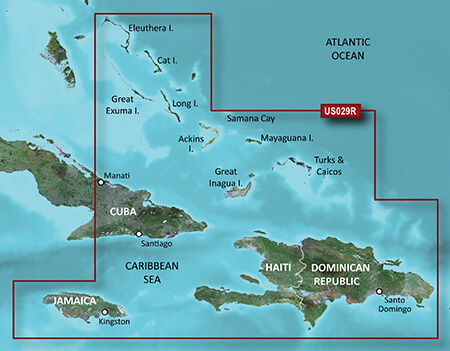
Provides detailed coverage of the eastern coast of the U.S. from Key West, FL to the Canadian border and the western coast from the Mexican border to Puget Sound, Alaska, Hawaii and major inland rivers, the U.S. Gulf Coast to the Mexican border and the Mexican Gulf Coast thru to the Yucatan. Canadian coverage includes the entire St. Lawrence Seaway, Nova Scotia and New Brunswick. The Great Lakes are covered in their entirety as are the Lake of the Woods. Coverage includes Prince Edward Island, Anticosti Island, Vancouver Island including the Inside and Outside Passages, Aleutian and Channel Islands, Bahamas, Turks and Caicos Islands, Cozumel, Cuba, Hispaniola, Puerto Rico and the U.S. Virgin Islands.
Specifications
| BlueChart g3 Vision | |
| Integrated Garmin and Navionics content | Yes |
| Auto Guidance technology | Yes |
| Depth range shading | Yes |
| Up to 1′ contours | Yes |
| Shallow water shading | Yes |
| Raster cartography | Yes |
| High-resolution relief shading | Yes |
| Unique 3-D views | Yes |
| High-resolution relief imagery | Yes |
| Aerial photos | Yes |
| BlueChart g3 | |
| Integrated Garmin and Navionics content | Yes |
| Auto Guidance technology | Yes |
| Depth range shading | Yes |
| Up to 1′ contours | Yes |
| Shallow water shading | Yes |
| Raster cartography | Yes |
Model: 010-C1019-20
- Provides industry-leading coverage, clarity and detail with updated coastal charts that feature integrated Garmin and Navionics® data
- Auto Guidance technology calculates a route using your desired depth and overhead clearance and provides a suggested path to follow
- Includes Depth Range Shading for up to 10 depth ranges, enabling you to view your target depth at a glance
- Up to 1’ contours provide a more accurate depiction of the bottom structure for improved fishing charts and navigation in swamps, canals and marinas
- NOAA raster cartography is available as a free downloadable feature via the ActiveCaptain® app
BlueChart g3 coastal charts provide industry-leading coverage, clarity and detail with integrated Garmin and Navionics data. Also included is Auto Guidance1 technology, which uses your desired depth and overhead clearance to calculate routes and provide a suggested path to follow — overlaid onto your chart. NOAA raster cartography is also available as a free downloadable feature via the ActiveCaptain app. It gives your chartplotter paper chartlike views of NOAA-surveyed areas in which individual points of interest are labeled with corresponding longitude and latitude information. Worldwide coverage is available by regions as accessory cards or via download; each region is sold separately.
The Auto Guidance feature calculates a suggested route using your desired depth and overhead clearance.
High-resolution relief shading combines color and shadow to give you an easy-to-interpret, clearer view of bottom structure than contour lines alone.
If you prefer your display to have the look of paper charts, NOAA raster cartography2 is available as a free downloadable feature via the ActiveCaptain® app.
This feature displays high-resolution Depth Range Shading for up to 10 depth ranges so you can view your designated target depth.
BlueChart g3 Vision charts feature 1’ contours that provide a more accurate depiction of bottom structure for improved fishing charts and enhanced detail in swamps, canals and port plans.
To aid in navigation, Shallow Water Shading allows map shading at a user-defined depth to give a clear picture of shallow waters to avoid.
Provides detailed coverage of the east coast of North America from Nain, NL to Raritan Bay, NY featuring Newfoundland, le d’Anticosti, New York Harbor and full U.S. and Canadian coverage of the Great Lakes in their entirety. The west coast of North America is covered from Glacier Bay, AK to Aberdeen, WA featuring British Columbia, Vancouver, the Queen Charlotte Islands and Puget Sound.
Integrated Garmin and Navionics contentYesAuto Guidance technologyYesDepth range shadingYesUp to 1′ contoursYesShallow water shadingYesRaster cartography YesHigh-resolution relief shadingNoUnique 3-D viewsNoHigh-resolution relief imageryNoAerial photosNo
Model: 010-C0728-20
- Provides industry-leading coverage, clarity and detail with updated coastal charts that feature integrated Garmin and Navionics® data
- Auto Guidance technology uses your desired depth and overhead clearance to calculate routes and show a suggested path to follow
- High-resolution relief shading combines color and shadow to give you an easy-to-interpret, clearer view of bottom structure than contour lines alone
- Depth Range Shading provides up to 10 depth ranges, enabling you to view your target depth at a glance
- Up to 1’ contours provide a more accurate depiction of the bottom structure for improved fishing charts and navigation in swamps, canals and marinas
- NOAA raster cartography is available as a free downloadable feature via the ActiveCaptain® app
BlueChart g3 coastal charts provide industry-leading coverage, clarity and detail with integrated Garmin and Navionics data. Also included is Auto Guidance technology, which uses your desired depth and overhead clearance to calculate routes and provide a suggested path to follow — overlaid onto your chart. NOAA raster cartography is also available as a free downloadable feature via the ActiveCaptain app. It gives your chartplotter paper chartlike views of NOAA-surveyed areas in which individual points of interest are labeled with corresponding longitude and latitude information. Worldwide coverage is available by regions as accessory cards or via download; each region is sold separately.
The Auto Guidance feature calculates a suggested route using your desired depth and overhead clearance.
This feature displays high-resolution Depth Range Shading for up to 10 depth ranges so you can view your designated target depth.
BlueChart g3 features up to 1’ contours, which provide a more accurate depiction of the bottom structure for improved fishing charts and navigation in swamps, canals and marinas.
To aid in navigation, Shallow Water Shading allows map shading at a user-defined depth to give a clear picture of shallow waters to avoid.
This feature gives your chartplotter paper chartlike views of NOAA-surveyed areas in which points of interest are labeled with corresponding longitude and latitude information.
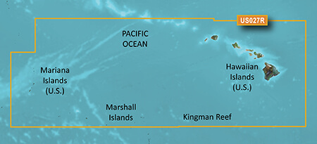
Coverage of the Pacific Ocean from the Hawaiian to Mariana Islands. Includes coverage of Guam, Midway, and Johnston Atoll. General coverage of Palmyra Atoll and the Marshall Islands also included.
Specifications
| BlueChart g3 Vision | |
| Integrated Garmin and Navionics content | Yes |
| Auto Guidance technology | Yes |
| Depth range shading | Yes |
| Up to 1′ contours | Yes |
| Shallow water shading | Yes |
| Raster cartography | Yes |
| High-resolution relief shading | Yes |
| Unique 3-D views | Yes |
| High-resolution relief imagery | Yes |
| Aerial photos | Yes |
| BlueChart g3 | |
| Integrated Garmin and Navionics content | Yes |
| Auto Guidance technology | Yes |
| Depth range shading | Yes |
| Up to 1′ contours | Yes |
| Shallow water shading | Yes |
| Raster cartography | Yes |
Model: 010-C0722-20
- Derived from official charts and private sources to provide navigational aids, spot soundings, depth contours, tides and currents, and detailed harbors and marinas
- Garmin Auto Guidance technology shows a suggested route to a destination
- Depth Range Shading for up to 10 depth ranges enables you to view your target depth at a glance
- Up to 1-foot contours provide a more accurate depiction of the bottom structure for improved fishing charts and navigation
- Shallow Water Shading feature allows for depth shading at a user-defined level to aid in navigation
- Unique 3D views like MarinerEye and FishEye provide additional perspective both above and below the water line
- High-resolution satellite imagery of ports, marinas, bridges and navigational landmarks for superior situational awareness
- Worldwide coverage available
- Keep your charts up to date with our industry-leading New Chart Guarantee and discount card update program
Detailed charts help the mariner guide their boat in and out of port with confidence.
Displays high-resolution Depth Range Shading for up to 10 depth ranges so you can view your designated target depth.
BlueChart g2 HD features 1-foot contours that provide a more accurate depiction of bottom structure for improved fishing charts and enhanced detail in swamps, canals and port plans.
Point Arena, CA to Puerto Vallarta, MX including Mendocino, San Francisco Bay, Channel Islands, San Diego,CA and the Baja Peninsula. General coverage for the Mexican coast including Cabo San Lucas, Mazatlan, Acapulco and Salina Cruz.
Specifications
| g2 HD | |
| 1′ HD Contours | Yes |
| Depth Range Shading | Yes |
| Shallow Water Shading | Yes |
| Navigational aids, spot soundings, depth contours, tides and currents and detailed harbors and marinas | Yes |
| g2 Vision HD | |
| 1′ HD Contours | Yes |
| Depth Range Shading | Yes |
| Shallow Water Shading | Yes |
| Navigational aids, spot soundings, depth contours, tides and currents and detailed harbors and marinas | Yes |
| Auto Guidance | Yes |
| 3-D Views (MarinerEye and FishEye) | Yes |
| High Resolution Satellite Imagery | Yes |
| Aerial Photography | Yes |
| Detailed coastal roads up to 5 miles inland | Yes |


Reviews
There are no reviews yet.